“Mountain Titlis from glacier to lake”
MountainTitlis from glacier to lake Mt. titlis and loke trudsee - go where the action is treat yourself to an unforgettable day out with snow
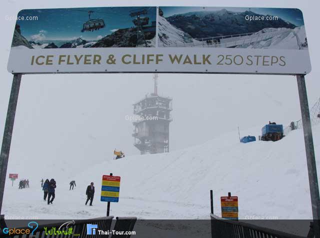
slides rowung and kick-scooter -or relax and savour the breathtaking 360° alpine paronama a trip in the ice flyer glacier chair lift a stroll through the Glacier Grocier park fun in the snow slides at the Glacier park : all this and more at 3,000 metres above sea level
Titlis straddles the border between Obwalden and Berne, its massif being also partially located in Nidwalden.
The mountain is located between the municipalities of Engelberg on the north and Gadmen on the south.
East of Titlis is the Grassen, where the borders between the cantons of Obwalden, Berne and Uri converge. The Geographical centre of Switzerland is situated about 15 kilometers west of the mountain.
Titlis is the highest mountain in the portion of the Urner Alps north of the Susten Pass.
This part of the range is located between the valleys of the Hasli (west) and the Reuss (east),
thus separating the waters feeding the basins of the Aar and Reuss respectively. On the north side the valley of Engelberg (Engelbergertal) is drained by the Engelberger Aa, a tributary of the Reuss. The valley is located southwards from Lake Lucerne. The northern side of the massif is covered by the Titlis Glacier (Titlisgletscher). The south steep and rocky face rises above the Wenden Glacier. The east side overlooks a glacier named Firnalpeligletscher.
History of Titlis Mountain
In earlier times, Titlis was known under the names Wendenstock or Nollen. The Reissend Nollen and the Wendenstöcke are the nearest western neighbours to the mountain, slightly lower than Titlis, but with sharp rugged peaks. In a document of 1435 the mountain is called Tuttelsberg (Tutilos mountain), referencing to a man named Tutilos, who was probably a local farmer. The name, from Tutilos Berg, became Titlisberg and later Titlis. The first ascent of Titlis was probably made in the year 1739. It was done by Ignaz Herz, J. E. Waser and two other men from Engelberg. The first written evidence of an ascent is found in the Engelberger Dokumente. They mention a party of four men that reached the summit in 1744.
On 21 January 1904 the first ski ascent of Titlis was made by Joseph Kuster and Willi Amrhein. In March 1967 the cable car to Klein Titlis (3,032 m) was inaugurated. In December 2012, the Titlis Cliff Walk opened to commemorate the 100th anniversary of the Engelberg-Gerschnialp cableway
Mountain Titlis
![]() luzern switzerland
Map
luzern switzerland
Map
![]() ไม่ทราบเวลาเปิดปิดที่แน่นอน
ไม่ทราบเวลาเปิดปิดที่แน่นอน
![]()
 1592
1592