


นาแห้ว ภูสวนทราย ป่าดิบ ริมชายแดน
 1970
1970
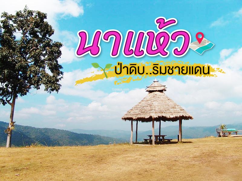 อำเภอนาแห้ว น้อยคนนักจะรู้จัก อำเภอเล็กกลางป่าเขา ชายแดนไทย-ลาว รอยต่อ จ.เลย-พิษณุโลก มากมายด้วยป่าดิบตามแนวชายแดน ไร้ผู้คน แต่มากด้วยความสมบูรณ์ทางธรรมชาติ ป่าผลัดใบผสม แหล่งป่าต้นน้ำ และสัตว์ป่า ได้แก่ เลียงผา หมาใน นกเหยี่ยว เต่าปูลู ฯลฯ
เชิญเที่ยวตามรอย GPS นี้ได้เลย สำหรับคนที่ชอบแหล่งท่องเที่ยวใหม่ๆ น่าลองมาสักครั้งเหมือนผม....
อำเภอนาแห้ว น้อยคนนักจะรู้จัก อำเภอเล็กกลางป่าเขา ชายแดนไทย-ลาว รอยต่อ จ.เลย-พิษณุโลก มากมายด้วยป่าดิบตามแนวชายแดน ไร้ผู้คน แต่มากด้วยความสมบูรณ์ทางธรรมชาติ ป่าผลัดใบผสม แหล่งป่าต้นน้ำ และสัตว์ป่า ได้แก่ เลียงผา หมาใน นกเหยี่ยว เต่าปูลู ฯลฯ
เชิญเที่ยวตามรอย GPS นี้ได้เลย สำหรับคนที่ชอบแหล่งท่องเที่ยวใหม่ๆ น่าลองมาสักครั้งเหมือนผม....

Wat Pho Chai Na Phueng is located in Ban Na Phueng, Na Haeo District — a border district known for its natural surroundings and traditional lifestyle. The temple has long served as a spiritual and cultural center of the community.
It is believed to have been built around the 17th–18th century (approximately 400–500 years ago), even before the establishment of Ban Na Phueng. It wa...
read more

Ban Muang Phrae is a small yet charming border village nestled in a valley alongside the Hueang River. Its landscape of mountains and riverside plains gives the area a cooler climate than much of Loei province, with light morning and evening mist creating a peaceful, slow-paced atmosphere ideal for relaxation.
The village’s defining feature is the Hueang River, which serves not only as a nat...
read more

Nam Tok Chang Tok is located within Phu Suan Sai National Park, Na Haeo District, Loei Province. It is one of the most scenic and well-known waterfalls in the park. The waterfall originates from the Phrae River, cascading over a cliff about 10 meters high and 20 meters wide, splashing onto the rocks below, creating a refreshing and cool atmosphere year-round.
The surrounding area is dense moist fo...
read more

Nam Tok Khing is part of the Phrae River, flowing over mountainous terrain. It has a height_ of approximately 5 meters and a width_ of about 25 meters. The water cascades over rocks, forming 2–3 tiers, creating large pools and a shaded, serene environment suitable for resting and safe swimming.
The surrounding area is dense montane rainforest with a wide variety of plants, including large tree...
read more

Tat Hueang Waterfall features a wide, cascading water curtain that drops into a deep pool below. Situated on the Hueang River, the waterfall marks the natural border between Thailand and Laos, earning it the nickname “Thai–Lao Friendship Waterfall.” From the waterfall, the right bank is Thailand (Phu Suan Sai National Park), and the left bank is Laos.
The surrounding area is cove...
read more

Noen 1255 is part of the high mountain ranges of Phu Suan Sai National Park, standing at 1,255 meters above sea level and about 1 km from Noen 1408, the highest point in the park. The surrounding terrain features complex mountains and dense highland forests.
Visitors can enjoy wide, expansive views, including the Thai–Laos border mountain ranges. During late rainy season to early winter (Sep...
read more

Wang Tat Waterfall is situated within Phu Suan Sai National Park in Na Haeo District, Loei Province. It is a large waterfall with scenic views year-round, especially during the rainy season when the water is abundant and flows rapidly into a large pool. Visitors can admire the cascading layers and the water flowing over natural rock formations.
The waterfall originates from the Phrae River, an imp...
read more

Phu Suan Sai National Park covers an area of approximately 73,225 rai (117 square kilometers), encompassing the high mountain ranges in the northern part of Loei Province, which continue to the border with Laos, with the Hueang River serving as a natural boundary.
The park’s terrain consists of complex mountains with elevations ranging from 600 to 1,408 meters above sea level. The highest pe...
read more
กำลังเป็นที่นิยม

8 World Heritage Sites of Thailand
Tracing Ancient Civilizations and Invaluable Forests Recognized by UNESCO Thaila..
Attractive Beaches in Sattahip, Chonburi
For those looking to escape the hustle and bustle of Pattaya and experience calm..
10 Thai Costume Spots to Go Back in Time
Wearing traditional Thai costume and taking photos at beautiful places is more t..
10 Must-Visit Spots Along the Chao Phraya River, B
Exploring the Chao Phraya River offers one of the most complete experiences of B..
Recommend trips
- The Four Holy Pilgrimage Sites
- Dream Destinations in Switzerland
- Pilgrimage to the Sacred Sites
- Trip to Bhutan
- 10 Sacred Buddhist Sites Thai Temples in India–Nep
- Top Paris Check-in Spots
- 10 Thai Costume Spots to Go Back in Time
- Must-Visit Check-in Spots in London
- Attractive Beaches in Sattahip, Chonburi
- 8 World Heritage Sites of Thailand
- The Ultimate Ancient Villages in Japan
- 10 Must-Visit Spots Along the Chao Phraya River, B
- 10 Best Shopping Destinations in Bangkok
- 10 Must-Visit Places in Waterford
- Watsons Bay Half-Day Trip
- 10 Must-Check-In Spots in Ireland
- Top 10 Must-Visit Spots in Pattaya
- Japan Bucket List: 20 Places You Must Visit Once i
- 10 Must-Visit Spots in Koh Yao
- EBC - World-Class Trekking Route