


จุดชมทะเลหมอกสวย ทั่วไทย
 17362
17362
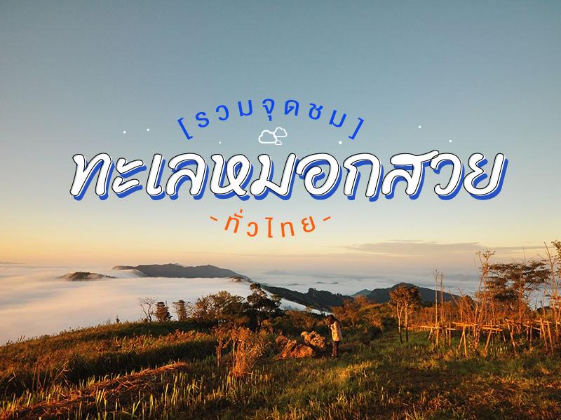 สถานที่ ชมทะเลหมอก เมืองไทย เราจัดไว้ให้ท่านชมตามพิกัด GPS นี้แล้ว

Doi Khad Pee Park Located in Ban Huai Chom Phu, Muang District, Chiang Rai. In the National Forest. Mae Lao left bank and Mae Kok right bank. The area is about 6,250 rai. It is the source of beautiful scenery of the local people. It is a tourist attraction. Both summer and winter Festivals and traditions. The sea of fog everywhere. It is only 180 degrees. But Doi Kad ...
read more


Doi Tung has many beautiful scenic spots.
Along the highway in 1149. viewpoint at km. 12 and 0.14 Kilometer.Along the Wat Noi Doi Tung - cliff house Bears. The road, which runs along the top of the mountain for many children. A viewpoint overlooking the panoramic view point on the mountain, like Moses on Doi Pha Chang Hee and Doi Pha Hom.Doi Tung has many beautiful viewpoint at....
read more


Phu Chi Fa is not just an ordinary viewpoint; it is an icon that anyone visiting Chiang Rai simply cannot miss. The name of the peak is derived from its amazing physical characteristic: a stone cliff with a sharp point pointing towards the sky. The tip of this cliff protrudes into Laos, meaning that when you stand at the peak, you experience standing on the edge of the sky with a clear view o...
read more

Doi Ang Khang Viewpoints (Doi Ang Khang Viewpoints) does not refer to a single viewpoint but rather a collection of major scenic viewpoints distributed along the mountain ridges and cliffs of Doi Ang Khang. The most popular destinations include Mon Son Viewpoint, Kiu Lom Viewpoint, and Ban Nor Lae Military Base Viewpoint, attracting both Thai and international visitors. Most of these locations are...
read more

Doi Inthanon National Park, located in Chiang Mai Province, is home to the highest peak in Thailand — Doi Inthanon, standing at 2,565 meters above sea level. The park spans over 482.4 square kilometers and covers parts of Chom Thong, Mae Chaem, Mae Wang, and Doi Lo districts.
Shaped by the Himalayan mountain range, the park features a landscape of rugged high mountains running north to south...
read more


Mon Sone Viewpoint is located on Doi Ang Khang within the Doi Pha Hom Pok National Park. It is a scenic viewpoint situated at an altitude of approximately 1,787 meters above sea level. This location features a wide terrace on a mountain ridge that offers a clear, panoramic view of the Dan Lao Mountain Range. During the winter and rainy seasons, Mon Sone Viewpoint is highly famous for its...
read more
7
Mon Jam


Mon Jam is a famous getaway destination located on a mountain ridge within the Nong Hoi Hmong village area. Originally, this land was a degraded forest used for shifting cultivation. However, through the grace of King Bhumibol Adulyadej the Great, who established the Nong Hoi Royal Project Development Center, this soil was revitalized into a thriving temperate agricultural hub. Situated at an alti...
read more


Doi Luang Chiang Dao stands as a limestone peak reaching 2,225 meters above sea level, featuring distinct geological characteristics that are rare in this region. The landscape from the summit is majestic, characterized by complex mountain ridges, particularly the Pyramid Peak and the Three Brothers Peaks, which are often enveloped in a thick sea of mist during the morning. Visitors can experience...
read more


Wat Phra That Doi Kong Mu is a significant and famous place, known as a sacred landmark of Mae Hong Son Province and an exceptionally beautiful viewpoint of the city.
This place has a long history, built in 1860 by Jong Tong Su, a wealthy Tai Yai merchant, who constructed the large pagoda to enshrine relics of Phra Moggallana Thera, brought from Mawlamyine, Myanmar. Later, in 1874, Phraya Sin...
read more
10
Mueang Pai

Mueang Pai (Pai) is a district renowned for its nature-focused tourism and easygoing lifestyle. The town is situated in a valley surrounded by majestic mountains and forests, providing clean air and a peaceful, tranquil setting.
The town has a fascinating history, most notably the Tha Pai Memorial Bridge, which was built during World War II and remains a significant landmark telling stories of the...
read more
11
Pang Ung


Pang Ung, officially known as the Pang Tong 2 Royal Project (Pang Ung), is a large reservoir on a high mountain peak, surrounded by magnificent pine forests, earning it the nickname "Switzerland of Thailand." It is one of Mae Hong Son province's most popular tourist destinations, attracting visitors to experience its natural beauty, especially during the winter.
This place has a long history. Orig...
read more

Wat Chan Royal Project is situated at Baan Den, Chang Mai Province 3-4 drive from Chiang Mai. Can visit Karen traditional and culture places, trekking sites and more nature things to see.
The project is divided into 1,000 acres planted each year, each family 40 acres and maintained for a period of five years to today. The government subsidized the planting approximately 9,400 a...
read more


Huai Nam Dang National Park spans across the rugged highlands of Mae Taeng District in Chiang Mai and Pai District in Mae Hong Son, serving as a vital natural corridor in Northern Thailand. Geographically, it is part of the Thanon Thong Chai Range, acting as a crucial headwater source for several major rivers, including the Mae Taeng and Pai Rivers. The geological landscape is characterized by ste...
read more
14
Doi Mon Jong


Doi Mon Chong stands at approximately 1,929 meters above sea level, located on the border between Omkoi District in Chiang Mai and Sam Ngao District in Tak. The terrain is unique for its contrasting geography: one side features gentle, sloping meadows, while the other presents a sheer vertical cliff dropping into the valley below. The name "Mon Chong" comes from the local Lanna language, meaning a...
read more

Doi Khun Tan National Park in the Lampang area holds immense significance as the starting point of a new chapter in northern Thailand's rail transportation. The Hang Chat District side of Lampang is the site of the Khun Tan Tunnel, the longest railway tunnel in Thailand (1,352.10 meters). Construction began during the reign of King Rama V under the supervision of German engineer Mr. Emil Eisenhofe...
read more

Phu Soi Dao National Park is the ultimate pride of the Thai trekking scene, especially during the rainy season when lush greenery covers every inch of the landscape. The journey begins with a heart-pounding trek through five brutal hills, starting from Sending Relatives Hill all the way to Death Hill (Neun Morana)a slope so steep that your face almost touches your knees. However, this is the perfe...
read more

Phayao Lake Viewpoint is part of the Phayao Lakeside Road, which has been developed into a public space for relaxation and various activities for the local community. It is an important landmark of Phayao Province, promoting natural tourism and outdoor activities.
Scenery The viewpoint offers expansive views of Phayao Lake with the backdrop of Doi Luang and a complex mountain range, making it idea...
read more


Doi Samer Dao and Pha Hua Sing are iconic destinations in Nan province, known for their panoramic mountain scenery and enchanting morning sea of mist. This spot attracts countless nature lovers who wish to immerse themselves in the serene beauty of northern Thailand.
What makes this site truly special is its spectacular sunrise and sunset viewpoints. Visitors often camp overnight to witness the sh...
read more

Doi Phu Kha National Park is the source of numerous streams and holds an ancient history tied to the legends of Nan’s people. Situated at an altitude of 1,980 meters above sea level, it covers an area of approximately 1,050,000 rai, spanning Pua, Chiang Klang, Thung Chang, Mae Charim, Tha Wang Pha, Santi Suk, and Bo Kluea Districts.
The terrain consists of steep, rugged mountains with stunni...
read more
20
Phu Thok

Phu Thok, located in Chiang Khan District, Loei Province, is one of the most popular destinations in northeastern Thailand for experiencing the sea of mist. Especially in the cool season, travelers flock here to witness the mesmerizing scenery of mist blanketing the valleys and flowing above the Mekong River, creating a magical and dreamlike atmosphere.
One of the highlights is the sunrise view. A...
read more
21
Khao Kho

Khao Kho is the definition of a vacation paradise in the lower northern region, earned the nickname Switzerland of Thailand. The name "Khao Kho" is derived from the Kho tree (Livistona speciosa), a palm species with fan-like leaves that grew abundantly in this area in the past. Beyond its atmosphere, the area holds significant history as a battlefield between the government and the Commu...
read more
22
Phu Tubberk


Phu Thap Boek is the highest mountain peak in Phetchabun Province and one of Thailand’s most popular destinations for nature lovers, photographers, and camping enthusiasts. Standing at approximately 1,768 meters above sea level, the mountain offers refreshing cool weather throughout the year. During winter, temperatures can drop to single digits, and frost can occasionally appear on the moun...
read more


Phu Ruea National Park covers areas in Phu Ruea and Tha Li districts of Loei Province, with its northern boundary adjoining Laos. The park’s terrain resembles a large ship perched atop a high mountain, with some rocks shaped as if sculpted, locally called “Kwan Samor.” Surrounding peaks are often shrouded in mist, creating a serene atmosphere amid lush forests, covering an area o...
read more
24
Phu Lom Lo


Phu Lom Lo is located in Kok Sathon Subdistrict, Dan Sai District, Loei Province, within Phu Hin Rong Kla National Park. The mountain sits on the border of three provinces: Phitsanulok, Phetchabun, and Loei, making it accessible from multiple routes.
Phu Lom Lo has been nicknamed "Thailand’s Sakura" as it is home to the largest plantation of Wild Himalayan Cherry trees in the country, coveri...
read more


Khao Chang Phueak (Khao Chang Phueak) is one of Thailand’s most famous and challenging trekking destinations, located within Thong Pha Phum National Park in Kanchanaburi Province. Rising approximately 1,249 meters above sea level, it is the highest peak in the park and is best known for its dramatic ridge trail called the “Knife Edge Ridge.”
The trekking route is approximate...
read more
26
Khao Krachom

Khao Krachom, located in Suan Phueng District, Ratchaburi Province, is one of the most famous viewpoints for observing the sea of mist and sunrise in western Thailand. Situated in the Tenasserim Mountains near the Thai-Myanmar border, it sits at an elevation of approximately 1,000–1,045 meters above sea level, resulting in cool temperatures year-round. During the rainy and winter seasons, ...
read more
27
Doi Hua Mot


Doi Hua Mot is a moderately low limestone mountain stretching across several connected ridgelines. Located in Umphang District, it is a popular scenic spot often included in travel routes that pair with a visit to Thi Lo Su Waterfall. The mountain’s signature charm lies in its bald-mountain terrain, where no large trees grow, leaving the slopes covered by short grasses, shrubs, and naturally...
read more
28
Pha Hin Kub


Pha Hin Kub is located south of the Khao Soi Dao mountain range and is a destination for trekkers who seek unspoiled nature and wish to test their physical endurance. The trek to conquer Pha Hin Kub is a 2-day, 1-night trip, covering a distance of approximately 6.5 - 7 kilometers and taking about 5-6 hours of walking. The trail is steep and may involve rope climbing in certain sections, earning th...
read more


Ayerweng Sea of Mist (Ayerweng Sea of Mist) is located on a high mountain area in Betong District at an elevation of approximately 2,038 feet above sea level within the Hala-Bala rainforest, one of the most biodiverse and important tropical rainforest ecosystems in southern Thailand. The landscape is characterized by complex mountain ranges and deep valleys, which create ideal conditions for dense...
read more
กำลังเป็นที่นิยม
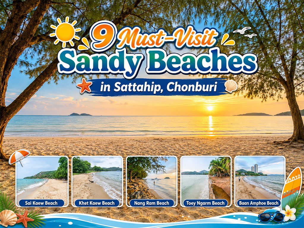
Attractive Beaches in Sattahip, Chonburi
For those looking to escape the hustle and bustle of Pattaya and experience calm..
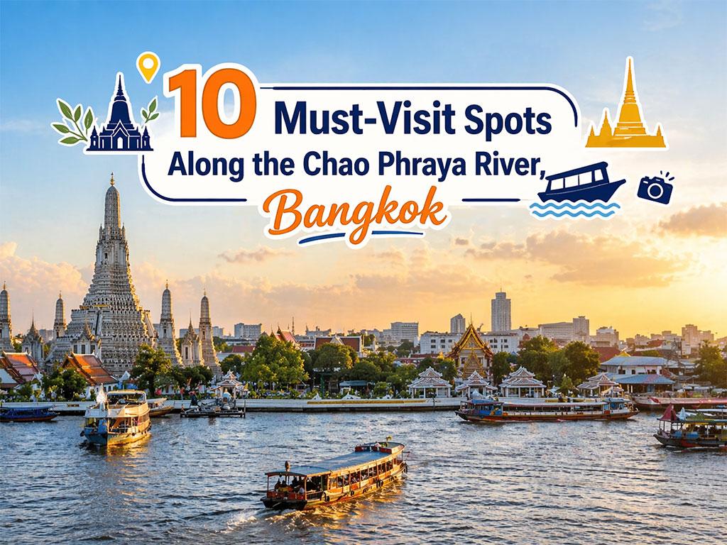
10 Must-Visit Spots Along the Chao Phraya River, B
Exploring the Chao Phraya River offers one of the most complete experiences of B..

8 World Heritage Sites of Thailand
Tracing Ancient Civilizations and Invaluable Forests Recognized by UNESCO Thaila..
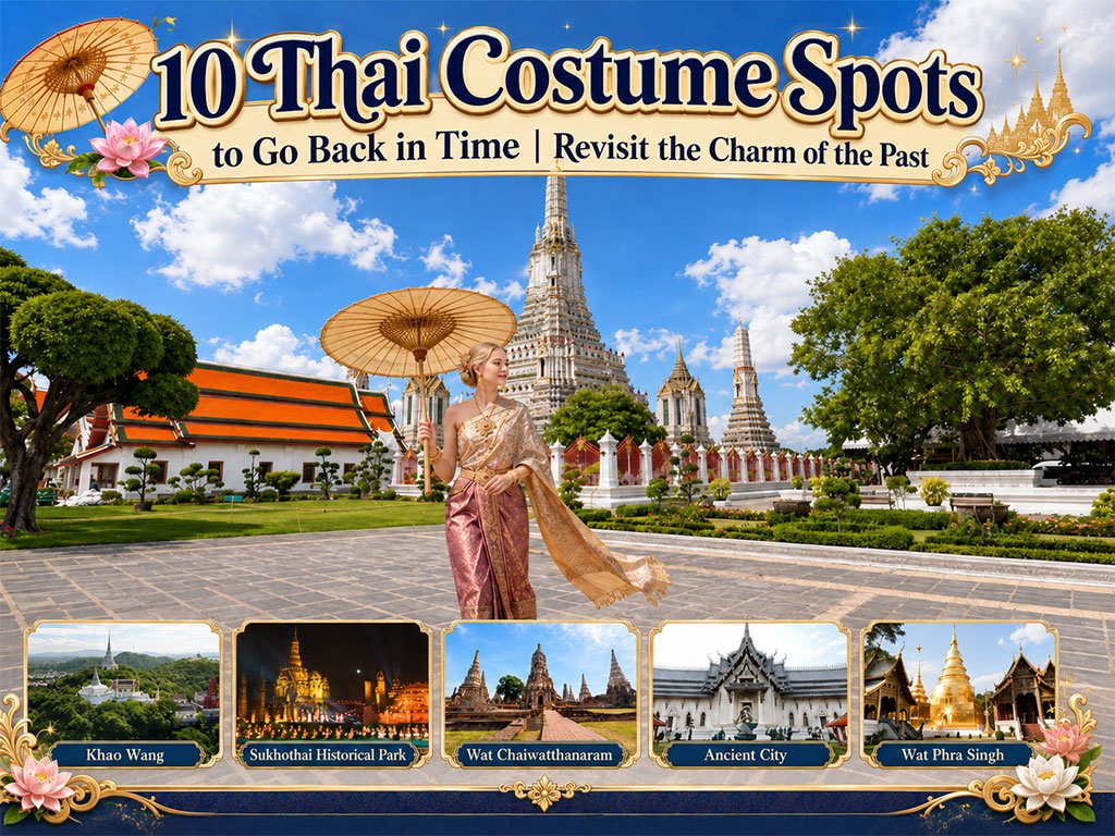
10 Thai Costume Spots to Go Back in Time
Wearing traditional Thai costume and taking photos at beautiful places is more t..
Recommend trips
- 10 Thai Costume Spots to Go Back in Time
- The Four Holy Pilgrimage Sites
- Dream Destinations in Switzerland
- Pilgrimage to the Sacred Sites
- Trip to Bhutan
- 10 Sacred Buddhist Sites Thai Temples in India–Nep
- Top Paris Check-in Spots
- Attractive Beaches in Sattahip, Chonburi
- Must-Visit Check-in Spots in London
- 10 Must-Visit Spots Along the Chao Phraya River, B
- 8 World Heritage Sites of Thailand
- The Ultimate Ancient Villages in Japan
- Watsons Bay Half-Day Trip
- 10 Best Shopping Destinations in Bangkok
- 10 Must-Visit Places in Waterford
- 10 Must-Check-In Spots in Ireland
- Top 10 Must-Visit Spots in Pattaya
- Thailand Nature Trails
- 1-Day Kirribilli & Sydney Harbour Walking Tour
- Japan Bucket List: 20 Places You Must Visit Once i