


10 Mountains to Discover on a Rainy Day
 10773
10773
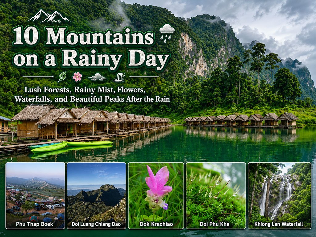
When the rain begins to fall, many mountains in Thailand transform into enchanting landscapes. Dry earth becomes lush, verdant forests; thin mist drifts along the mountain slopes; wild flowers begin to bloom; waterfalls regain their power; and rice fields in the valleys turn a vibrant green. This is a time when nature's beauty is not striking, but rather soft, serene, and full of life.
“10 Mountains to Discover on a Rainy Day” is a collection of mountains and natural areas that invite you to explore the charm of the rainy season from various perspectives. It begins with Pa Hin Ngam National Park and its pinkish-purple Dok Krachiao (Siam Tulip) Field amidst the mist; Phu Suan Sai National Park, with its rich hill evergreen forests and a sea of mist along the Thai-Lao border; Phu Thap Boek, known for its complex mountain ranges, vegetable farms amidst the fog, and winding ridge roads; and Khao Sok National Park, a beautiful rainforest in the south, graced with limestone mountains, misty rain, waterfalls, and lush nature after the downpour.
Next, we have Doi Luang Chiang Dao, a magnificent limestone peak enveloped by thick clouds on a rainy day; Ban Pa Bong Piang, offering a panoramic view of emerald green rice terraces stretching across the valley; Doi Phu Kha National Park, rich with ancient, moist forests, vibrant green moss, and mist drifting through the mountain range; and Khun Sathan National Park, a tranquil place abundant with evergreen forests, waterfalls, and morning mist.
For nature trail lovers, Phu Soi Dao National Park is one of the iconic images of the rainy season, featuring fields of blooming purple Dok Hong Naak (Impatiens) flowers, Sai Thip Waterfall, and emerald green moss on the high pine plains. Meanwhile, Khlong Lan National Park completes the collection with the powerful cascade of a large waterfall plunging from a high cliff, surrounded by mountains and a complete ecosystem, inviting you to experience the refreshing vibrancy of the forest as its waterways come alive.
This collection doesn't invite us to find the “most famous mountains,” but rather to get to know mountains on days when nature is breathing fully. Days when the rain freshens the leaves, the mist softens the views, the waterfalls energize the forest, and ordinary trails transform into more beautiful memories than imagined. If you have a rainy-day mountain experience you'd like to recommend, please share your experiences and memorable photos to help this collection inspire future travelers.


กำลังเป็นที่นิยม

Doi Inthanon is the highest mountain in Thailand, located within Doi Inthanon Na..

This route comprehensively gathers Nan's important historical, religious, artist..

Wearing traditional Thai costume and taking photos at beautiful places is more t..

Chiang Mai is not just about temples and Lanna culture; it also boasts vast fore..
Recommend trips
- The Four Holy Pilgrimage Sites
- 10 Must-Visit Checkpoints in Nan
- Dream Destinations in Switzerland
- 10 Thai Costume Spots to Go Back in Time
- 12 Tourist Attractions Doi Inthanon
- Pilgrimage to the Sacred Sites
- Trip to Bhutan
- 10 Sacred Buddhist Sites Thai Temples in India–Nep
- Top Paris Check-in Spots
- Must-Visit Check-in Spots in London
- 10 Must-Visit Spots Along the Chao Phraya River, B
- 8 World Heritage Sites of Thailand
- Chiang Mai's Ultimate National Parks
- The Ultimate Ancient Villages in Japan
- Watsons Bay Half-Day Trip
- 10 Must-Visit Places in Waterford
- 10 Best Shopping Destinations in Bangkok
- EBC - World-Class Trekking Route
- 10 Must-Visit Check-ins in Uthai Thani
- Giant Buddha Landmarks in Thailand