


ที่สุดเมืองไทย
 4122
4122
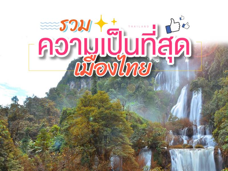 ที่สุด เมืองไทย....
น่าจะพอเดากันออกว่า ที่สุดอย่างไรกันบ้าง
มี อุทยานแห่งชาติสองแห่ง ลองเดากันดุครับ ว่าที่สุดอย่างไร...
ที่สุด เมืองไทย....
น่าจะพอเดากันออกว่า ที่สุดอย่างไรกันบ้าง
มี อุทยานแห่งชาติสองแห่ง ลองเดากันดุครับ ว่าที่สุดอย่างไร...

Mae Sai Border Checkpoint began as the most significant strategic trade hub in Northern Thailand, with the narrow Sai River serving as the natural boundary. The Thai-Myanmar Friendship Bridge stands prominently as a long-standing symbol of diplomacy and friendship between the two nations. A key point of interest is that this location marks the end of Phahonyothin Road (Highway 1), which stretches ...
read more

Singkhorn Border Checkpoint Singkhon Pass was developed as a Special Temporary Border Checkpoint and plays a significant role in trade, investment, and cultural exchange between Thailand and Myanmar. The border market attracts tourists and traders, offering local Thai products as well as Burmese items and regional souvenirs.
Economic Role: Singkhon Pass is part of the route connecting Thailand's W...
read more

The Kra Isthmus is located in Kraburi District, Ranong Province, and is recognized as the narrowest part of the Malay Peninsula. It measures approximately 44 kilometers in width_, stretching from the Andaman Sea on the west coast to the Gulf of Thailand on the east.
Geographically, the area is highly significant as it marks the boundary between mainland Asia and the Malay Peninsula. It also forms p...
read more

Salawin National Park is an important and well-known natural attraction, celebrated for its spectacular views of the Salawin River, which flows along the Thai-Myanmar border. With a landscape of complex, interwoven mountain ranges, it is an ideal destination for those seeking tranquility and pristine nature.
The park was established on November 9, 1994, covering areas in Mae Sariang and Sob Moei d...
read more


Top of Doi Inthanon is the highest peak of the Thanon Thong Chai Range and the highest point in Thailand, reaching an altitude of 2,565 meters above sea level. Originally known as Doi Ang Ka (Crow’s Pond Mountain) due to a natural pond where crows gathered, its history changed significantly during the reign of King Inthawichayanon, the 7th ruler of Chiang Mai. The King loved and cherish...
read more


Thi Lo Su Waterfall is a gigantic limestone waterfall cascading down a steep cliff over 250–300 meters high. Its powerful flow resonates throughout the valley all year long. The original Karen term “Thi Lo Chue” means “water that falls forcefully and crashes onto the ground”, but the name was later mispronounced as “Thi Lo Su,” which some mistakenly transl...
read more

Mon Bridge, officially known as the "Uttamanusorn Bridge," is located in Sangkhlaburi District, Kanchanaburi Province. It's a wooden bridge spanning the Songkalia River and is considered the longest wooden bridge in Thailand, measuring approximately 850 meters. While some engineering estimates differ slightly, the widely accepted figure for tourism and local authorities is around 850 meters, refle...
read more

Sirikit Dam is a massive earth-core dam built across the Nan River in Tha Pla District, Uttaradit Province. It is the largest earth dam in Thailand and one of the most important water resource development projects in northern Thailand. Originally named "Pha Som Dam" after the rock formations near its construction, it was officially named after Her Majesty Queen Sirikit, the Queen Mother, in 1968. ...
read more


Muang Temple is one of the most important landmarks of Ang Thong Province that almost every visitor should not miss. Its remarkable history lies in the restoration and revival of the temple from an abandoned site into a magnificent Buddhist sanctuary under the guidance of Luang Pho Kasem Ajarn Supho, a former abbot who played a crucial role in developing the temple into a major center of fait...
read more

Bueng Boraphet is far more than just a scenic natural attraction in Nakhon Sawan; it is recognized as a Wetland of International Importance (Ramsar Site), featuring a complex and delicate ecosystem. This vast lake serves as a permanent habitat and a crucial migratory sanctuary for hundreds of species of aquatic animals and birds. Furthermore, it functions as a vital freshwater fishing hub that has...
read more

Chatuchak Weekend Market, also known as JJ Market, is one of the largest weekend markets in the world and a top shopping destination in Bangkok. Spanning over 27 acres with more than 15,000 stalls, the market welcomes hundreds of thousands of visitors each weekend.
The market is organized into clearly defined sections, including fashion apparel, home décor, vintage collectibles, plants and ...
read more


Pha Taem National Park is located in Khong Chiam District, Ubon Ratchathani Province, covering an area of about 340 square kilometers. The terrain is mainly composed of rugged high mountains, cliffs along the Mekong River, dry dipterocarp forests, mixed deciduous forests, and natural rock plateaus, home to diverse flora and fauna.
Before it was declared a national park, the Pha Taem area had been ...
read more

The World's Largest Postbox Community Center is far more than just an aesthetic structure; it stands as a "Monument of Communication." It was built to honor the legacy of Betong’s very first postbox, which dates back to 1924. The concept for this colossal replica was born when the Betong Municipality realized that the original postbox at the Clock Tower—located on a narrow sidewal...
read more

The Southernmost Point of Thailand is one of Thailand’s most meaningful landmarks, both geographically and symbolically. It is not just a popular photo spot, but also represents the “end of Thailand’s road network” — the southernmost point that can be reached by car.
Geographically, it is located in Harapan Village, Yarom Subdistrict, Betong, Yala, near the border che...
read more
กำลังเป็นที่นิยม
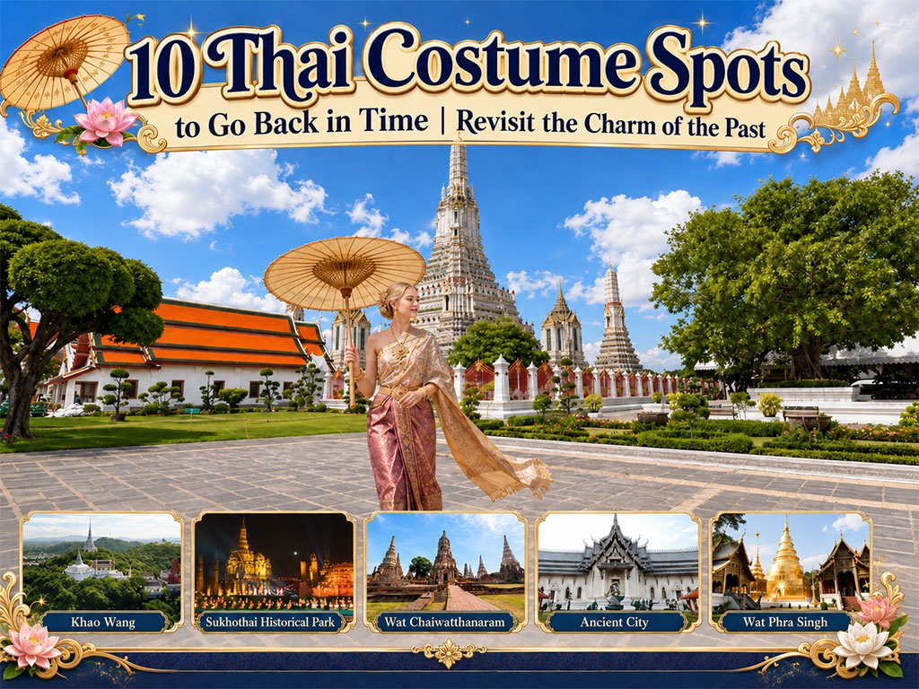
10 Thai Costume Spots to Go Back in Time
Wearing traditional Thai costume and taking photos at beautiful places is more t..
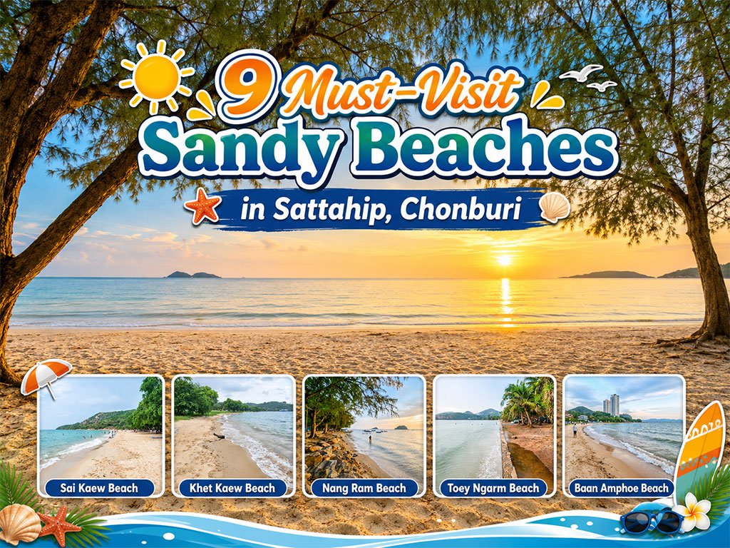
Attractive Beaches in Sattahip, Chonburi
For those looking to escape the hustle and bustle of Pattaya and experience calm..

10 Kanchanaburi Spots When the Rain Softly Falls
Kanchanaburi when the rain softly falls is a beautiful moment between the end of..
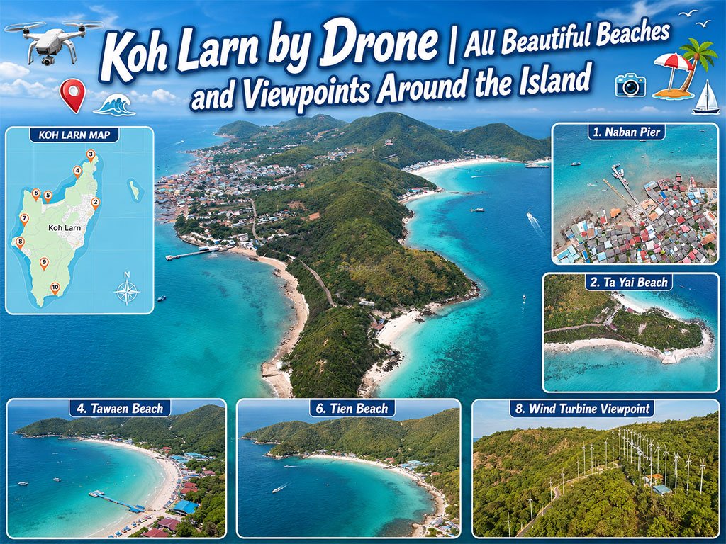
Koh Larn Aerial Views by Drone
Starting from Naban Pier, then looping north to Ta Yai Beach → Th..
Recommend trips
- The Four Holy Pilgrimage Sites
- Dream Destinations in Switzerland
- Pilgrimage to the Sacred Sites
- Trip to Bhutan
- 10 Sacred Buddhist Sites Thai Temples in India–Nep
- Koh Larn Aerial Views by Drone
- 10 Kanchanaburi Spots When the Rain Softly Falls
- Top Paris Check-in Spots
- 10 Thai Costume Spots to Go Back in Time
- Must-Visit Check-in Spots in London
- Attractive Beaches in Sattahip, Chonburi
- Thailand’s Sandbar Wonders
- 10 Must-Visit Spots Along the Chao Phraya River, B
- 8 World Heritage Sites of Thailand
- The Ultimate Ancient Villages in Japan
- 10 Must-Visit Places in Waterford
- 10 Best Shopping Destinations in Bangkok
- Japan Bucket List: 20 Places You Must Visit Once i
- 10 Must-Visit Spots in Koh Yao
- EBC - World-Class Trekking Route