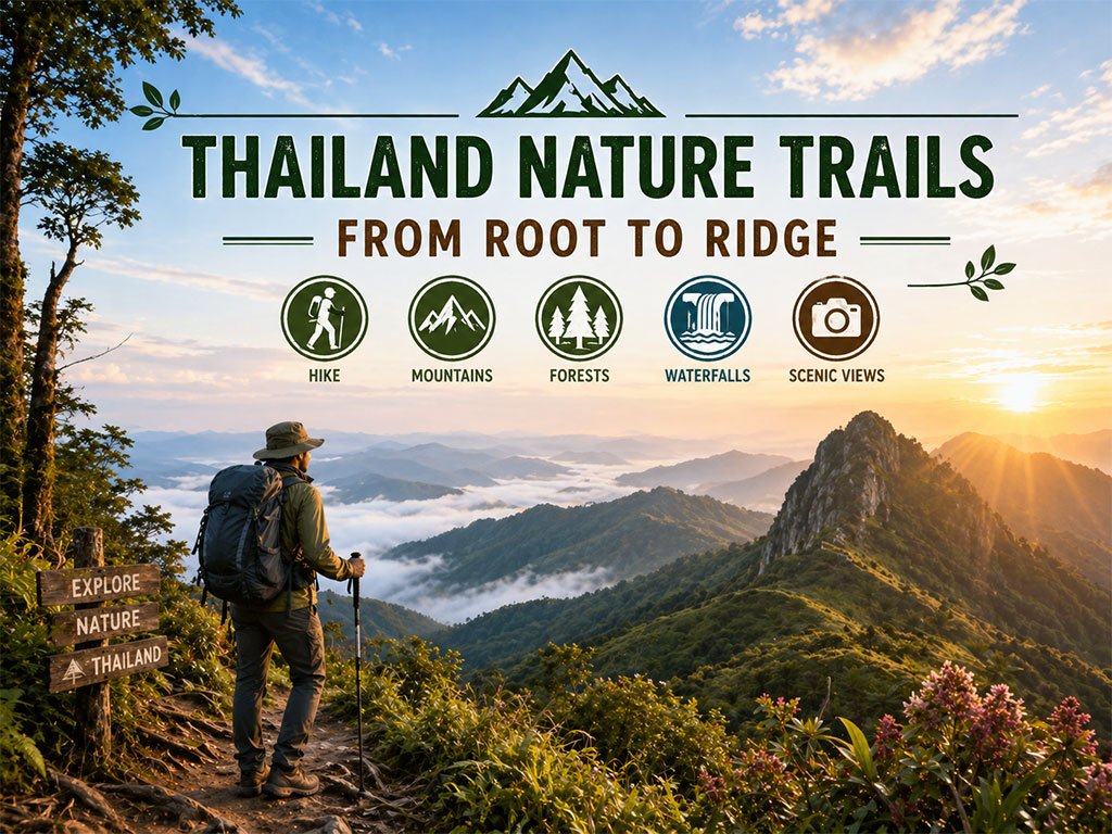
Thailand offers one of the most diverse ranges of nature trails in Southeast Asia, from short interpretive forest walks to challenging summit treks across dramatic mountain landscapes. These routes reveal the country’s rich ecosystems—from tropical evergreen forests and pine ridges to high-altitude cloud forests and limestone peaks rarely found elsewhere in the region.
One of the most unique experiences begins along the Ang Ka Nature Trail in Doi Inthanon National Park, the highest point in Thailand, where visitors walk through rare highland peat forest covered with moss and alpine vegetation. Nearby, the Kew Mae Pan Nature Trail offers spectacular ridge-top viewpoints and seasonal rhododendron blooms during the cool season.
For more adventurous hikers, Doi Luang Chiang Dao in Chiang Dao Wildlife Sanctuary stands among Thailand’s most iconic limestone summits and forms part of a globally recognized biosphere landscape. Likewise, Phu Kradueng National Park remains one of the country’s classic trekking destinations and a symbolic mountain journey for Thai travelers.
Further north, Doi Phu Kha National Park is known for rare plant species and scenic mist viewpoints, while Phu Soi Dao National Park rewards hikers with pine savanna plateaus and seasonal purple wildflower fields during the rainy season.
In western Thailand, the journey to Thi Lo Su Waterfall inside Umphang Wildlife Sanctuary combines trekking, river travel, and off-road adventure through one of the country’s most pristine forest regions.
Some trails also connect nature with local culture, such as the Pha Dok Siew Waterfall Trail in Doi Inthanon National Park, which passes Karen villages and hillside coffee farms, and Nor Lae village near Doi Ang Khang, where visitors can enjoy panoramic borderland scenery above the morning mist.
Whether beginning with a gentle forest boardwalk or challenging yourself on one of Thailand’s legendary summit routes, these trails offer unforgettable encounters with mountains, waterfalls, cloud seas, and highland landscapes. From root to ridge, each step reveals a different dimension of Thailand’s natural beauty—and may become one of the most rewarding journeys you experience in a lifetime.
Ang Ka Nature Trail has a fascinating and long history associated with the exploration of Doi Inthanon. Originally, this area was called Doi Ang Ka (Crow's Pond Mountain) after a natural pond on the summit where large flocks of crows used to gather to bathe, which eventually became the source of its name. The area has been studied by foreign zoologists and botanists since before World War II becau...
read more
Kew Mae Pan Nature Trail holds significant history as one of the pioneer ecotourism projects under Doi Inthanon National Park. In the local Northern dialect, "Kew" means a narrow and tapering mountain ridge, while "Mae Pan" refers to the stream flowing below. This trail was developed to be the most complete "nature classroom," focusing on educating visitors about headwater ecosystems and the inter...
read more
Pha Dok Siew Waterfall (Pha Dok Siew Waterfall)—known to many as "Rak Jang Waterfall" after a Thai movie filmed here—offers one of the most authentic and rewarding trekking routes in Doi Inthanon National Park, the “Roof of Thailand.” The trail is community-managed by the Karen Hill Tribe, who live in harmony with the forest and guide visitors through their ancestral land.
...
read more
Doi Luang Chiang Dao stands as a limestone peak reaching 2,225 meters above sea level, featuring distinct geological characteristics that are rare in this region. The landscape from the summit is majestic, characterized by complex mountain ridges, particularly the Pyramid Peak and the Three Brothers Peaks, which are often enveloped in a thick sea of mist during the morning. Visitors can experience...
read more
Ban Nor Lae is a hill tribe village inhabited mainly by the Palaung people, also known locally as the Dara-ang ethnic group. The village is located at the far end of the Doi Ang Khang mountain road near the Thailand–Myanmar border in Fang District, Chiang Mai Province. Most villagers migrated from Shan State in Myanmar in 1984 and were granted settlement under the royal patronage of Thailand...
read more
Doi Suthep-Pui National Park covers areas in Mae Rim, Hang Dong, and Mueang Chiang Mai districts, with an area of approximately 262.50 square kilometers (163,162.50 rai). It consists of rich forests and complex mountains, including Doi Suthep (1,667 m), Doi Buak Ha, and Doi Pui (highest 1,685 m), which are the sources of important streams.
Major attractions and important sites within the park:
W...
read more
Mae Yen Waterfall is one of the most beautiful waterfalls in Pai, Mae Hong Son province. However, getting there requires a significant amount of effort, as you have to trek deep into the jungle.
The waterfall is a three-tiered cascade, approximately 30 meters high, with a large pool at the bottom where you can swim.
The journey is a long and challenging trek, making it suitable for those who love ...
read more
Doi Phu Kha National Park is the source of numerous streams and holds an ancient history tied to the legends of Nan’s people. Situated at an altitude of 1,980 meters above sea level, it covers an area of approximately 1,050,000 rai, spanning Pua, Chiang Klang, Thung Chang, Mae Charim, Tha Wang Pha, Santi Suk, and Bo Kluea Districts.
The terrain consists of steep, rugged mountains with stunni...
read more
Phu Soi Dao National Park (Phu Soi Dao National Park) is one of the most remarkable trekking destinations in Uttaradit Province. The highest peak reaches 2,102 meters above sea level, ranking as the 4th highest mountain in Thailand, with cool weather year-round and mountainous terrain along the Thai–Lao border.
Natural Highlights:
The highlight is the vast Phu Soi Dao Pine Field, a unique hi...
read more
Si Satchanalai National Park, formerly known as Mae Yom Forest, is one of the most significant and beautiful natural attractions in Sukhothai Province. Most of the area consists of steep mountains covered by lush deciduous and dry evergreen forests. This forest is a vital headwater source for many rivers that sustain the lives of people in Sukhothai and nearby provinces. The atmosphere within the ...
read more
Thi Lo Su Waterfall is a gigantic limestone waterfall cascading down a steep cliff over 250–300 meters high. Its powerful flow resonates throughout the valley all year long. The original Karen term “Thi Lo Chue” means “water that falls forcefully and crashes onto the ground”, but the name was later mispronounced as “Thi Lo Su,” which some mistakenly transl...
read more
Mae Wong National Park covers Pang Sila Thong District in Kamphaeng Phet and Mae Wong/Mae Poen Districts in Nakhon Sawan, with a total area of 894 sq.km. It forms part of the Western Forest Complex and represents one of Thailand’s most important watershed forests, feeding streams such as Khlong Mae Wong and many tributaries. The park was officially designated on 14 September 1987.
The forest...
read more
Khao Chang Phueak (Khao Chang Phueak) is one of Thailand’s most famous and challenging trekking destinations, located within Thong Pha Phum National Park in Kanchanaburi Province. Rising approximately 1,249 meters above sea level, it is the highest peak in the park and is best known for its dramatic ridge trail called the “Knife Edge Ridge.”
The trekking route is approximate...
read more
Phu Kradueng National Park is a sandstone table-top mountain shaped like an inverted bell, covering approximately 348 square kilometers (217,575 rai). It was declared Thailand’s second national park in 1959 (B.E. 2502).
The summit plateau is about 60 square kilometers, serving as the main area for overnight stays and nature exploration. The Wang Kwang Visitor Center provides accommodation, c...
read more
Khao Yai National Park is Thailand’s first national park, established on September 18, 1962, covering an area of over 2,168 square kilometers across four provinces: Nakhon Ratchasima, Prachinburi, Nakhon Nayok, and Saraburi. In 2005, it was declared a UNESCO World Heritage Site as part of the Dong Phayayen–Khao Yai Forest Complex.
The park features a mix of evergreen forests, grassland...
read more


 1482
1482