


เที่ยวตามทาง ระนอง
 2442
2442
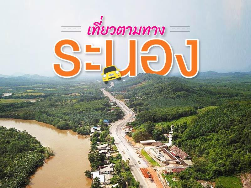 ทริปนี้เน้นขับรถเที่ยว ล่องใต้เส้นทางที่สวยสุดๆ แห่งหนึ่ง ของเมืองไทย
จ.ระนอง แร่นอง เมืองที่มีประวัติศาสตร์ ดินแดนฝน 3 ฤดู ถนนเลียบทะเลอันดามัน อีกด้านเป็นป่าเขาดิบชื้นสูงตลอดจังหวัด จึงมากมายด้วยแหล่งท่องเที่ยวทางธรรมชาติ
หากเดินทางมาจากชุมพร แยกเลี้ยวออกมาจากสี่แยกปฐมพร หากจะเน้นเทียวระนอง ไม่ใช่ทางผ่าน คงต้องแวะอย่างน้อย 1 คืน ที่ตัวเมืองระนอง ที่พักที่นี่ราคาไม่แพง ประมาณ800-1200 บ. ก็อย่างดีแล้ว
ผมกำหนดสถานที่ท่องเที่ยวจังหวัดระนองตลอดทางผ่าน แบบไม่ต้องเสียเวลาตีรถเข้าไปลึกๆ จัดออกครับ เริ่มต้นที่
ศิลาสลัก จปร (ร.5) พบที่แห่งนี้หมายความว่า เริ่มเข้า เขต จ.ระนอง
แวะซื้อทับหลี สัก 1-2 กล่อง เลือกร้านเองได้เลย เก็บไว้ทานระหว่างทาง เด่วคงได้หิว
คอคอดกระ ส่วนที่แคบที่สุดของแหลมมาลายู หลายคนจำผิดว่าแคบที่สุดของประเทศไทย จังหวัดขับรถแถวนี้จะเร็ว จะแล่นเลยไปต้องสังเกตุป้ายบอกทางดีๆ แวะชม ถ่ายรูปสัก 5 นาที คอคอดกระอยู่ริมทางหลวง-เพชรเกษม
ถ้ำพระขยางค์ ริมทาง เป็นถ้ำที่ไม่ลึก แวะศัการะสิ่งศักดิ์สิทธิ์และความสวยงามของถ้ำ ควรติดไฟฉายไปด้วย
เขาฝาชี เกาะน้อยใหญ่ ปากแม่น้ำ ทางออกสู่ทะเลอันดามัน ยามเย็น อาทิตย์ตกที่นี่จัดว่าสวยสุดๆแห่งหนึ่งของเมืองไทย แต่กลางวันก็สวยไปอีกแบบ ต้องขับรถขึ้นเขา ทางแคบหน่อย โปรดขับอย่างระมัดระวัง
น้ำตกปุญญบาล ช่วงหน้าแล้ง น้ำน้อย เป็นน้ำตกริมทางหลวง จอดรถเดินเล่น ได้เลย
หากเป็นไปตามเวลา ผมเดาว่าน่าจะมาถึงเวลาเย็นพอดี ต้องเดินทงอีกไกล แวะพักที่ตัวเมืองก่อน หาที่พัก จ.ระนอง แนะนำ http://www.โรงแรมระนอง.com เช็คอินเรียบร้อย อาจเดินหาร้านอาหารใกล้ที่พักดู
เช้ารุ่งขึ้น แนะนำพระราชวังรัตนรังสรรค์ ชมสถาปัตยกรรมไม้ น่าจะใช้เวลาสัก 20-30 นาที แล้วต่อไปที่น้ำพุร้อนระนอง
ที่ระนองมีบ่อน้ำพุร้อน หลายแห่ง ที่ดังสุด ใหญ่ที่สุด ก็ที่นี่อยู่ในเขตตัวเมืองระนอง หากต้องการอาบหรือแช่ตัว ผมแนะนำอีกที่ถัดไป น้ำพุร้อนพรรั้ง แช่ได้เต็มๆ
ผ่านเลยมา ภูเขาหญ้า ยามเช้าๆ หรือเย็นๆ จะสวย เวลาอื่นผมไม่แนะนำ
ตบท้ายทริประนอง ด้วย อุทยานแห่งชาติดแหลมสน เดินเล่นชายหาด อาจใช้เวลาขับรถแยกมาจากถนนใหญ่หน่อย ถ้ามีเวลาก็คุ้มค่า หากมีเวลาสักครึ่งวัน ผมแนะนำติดต่ออุทยานฯ เช่าเรือเหมาลำไป เที่ยวหมุ่เกาะกำ สุดยอด....ผมไปมาแล้ว
ทริปนี้เน้นขับรถเที่ยว ล่องใต้เส้นทางที่สวยสุดๆ แห่งหนึ่ง ของเมืองไทย
จ.ระนอง แร่นอง เมืองที่มีประวัติศาสตร์ ดินแดนฝน 3 ฤดู ถนนเลียบทะเลอันดามัน อีกด้านเป็นป่าเขาดิบชื้นสูงตลอดจังหวัด จึงมากมายด้วยแหล่งท่องเที่ยวทางธรรมชาติ
หากเดินทางมาจากชุมพร แยกเลี้ยวออกมาจากสี่แยกปฐมพร หากจะเน้นเทียวระนอง ไม่ใช่ทางผ่าน คงต้องแวะอย่างน้อย 1 คืน ที่ตัวเมืองระนอง ที่พักที่นี่ราคาไม่แพง ประมาณ800-1200 บ. ก็อย่างดีแล้ว
ผมกำหนดสถานที่ท่องเที่ยวจังหวัดระนองตลอดทางผ่าน แบบไม่ต้องเสียเวลาตีรถเข้าไปลึกๆ จัดออกครับ เริ่มต้นที่
ศิลาสลัก จปร (ร.5) พบที่แห่งนี้หมายความว่า เริ่มเข้า เขต จ.ระนอง
แวะซื้อทับหลี สัก 1-2 กล่อง เลือกร้านเองได้เลย เก็บไว้ทานระหว่างทาง เด่วคงได้หิว
คอคอดกระ ส่วนที่แคบที่สุดของแหลมมาลายู หลายคนจำผิดว่าแคบที่สุดของประเทศไทย จังหวัดขับรถแถวนี้จะเร็ว จะแล่นเลยไปต้องสังเกตุป้ายบอกทางดีๆ แวะชม ถ่ายรูปสัก 5 นาที คอคอดกระอยู่ริมทางหลวง-เพชรเกษม
ถ้ำพระขยางค์ ริมทาง เป็นถ้ำที่ไม่ลึก แวะศัการะสิ่งศักดิ์สิทธิ์และความสวยงามของถ้ำ ควรติดไฟฉายไปด้วย
เขาฝาชี เกาะน้อยใหญ่ ปากแม่น้ำ ทางออกสู่ทะเลอันดามัน ยามเย็น อาทิตย์ตกที่นี่จัดว่าสวยสุดๆแห่งหนึ่งของเมืองไทย แต่กลางวันก็สวยไปอีกแบบ ต้องขับรถขึ้นเขา ทางแคบหน่อย โปรดขับอย่างระมัดระวัง
น้ำตกปุญญบาล ช่วงหน้าแล้ง น้ำน้อย เป็นน้ำตกริมทางหลวง จอดรถเดินเล่น ได้เลย
หากเป็นไปตามเวลา ผมเดาว่าน่าจะมาถึงเวลาเย็นพอดี ต้องเดินทงอีกไกล แวะพักที่ตัวเมืองก่อน หาที่พัก จ.ระนอง แนะนำ http://www.โรงแรมระนอง.com เช็คอินเรียบร้อย อาจเดินหาร้านอาหารใกล้ที่พักดู
เช้ารุ่งขึ้น แนะนำพระราชวังรัตนรังสรรค์ ชมสถาปัตยกรรมไม้ น่าจะใช้เวลาสัก 20-30 นาที แล้วต่อไปที่น้ำพุร้อนระนอง
ที่ระนองมีบ่อน้ำพุร้อน หลายแห่ง ที่ดังสุด ใหญ่ที่สุด ก็ที่นี่อยู่ในเขตตัวเมืองระนอง หากต้องการอาบหรือแช่ตัว ผมแนะนำอีกที่ถัดไป น้ำพุร้อนพรรั้ง แช่ได้เต็มๆ
ผ่านเลยมา ภูเขาหญ้า ยามเช้าๆ หรือเย็นๆ จะสวย เวลาอื่นผมไม่แนะนำ
ตบท้ายทริประนอง ด้วย อุทยานแห่งชาติดแหลมสน เดินเล่นชายหาด อาจใช้เวลาขับรถแยกมาจากถนนใหญ่หน่อย ถ้ามีเวลาก็คุ้มค่า หากมีเวลาสักครึ่งวัน ผมแนะนำติดต่ออุทยานฯ เช่าเรือเหมาลำไป เที่ยวหมุ่เกาะกำ สุดยอด....ผมไปมาแล้ว

Royal Initials Rocks is a historically significant landmark that reflects the administrative vision and dedication of King Chulalongkorn, who initiated royal journeys across the country to personally observe and improve the living conditions of his people.
In 1890 (Rattanakosin Era 109), the King traveled to the southern coastal regions of Thailand, including Ranong, which at the time was an ...
read more

The Kra Isthmus is located in Kraburi District, Ranong Province, and is recognized as the narrowest part of the Malay Peninsula. It measures approximately 44 kilometers in width_, stretching from the Andaman Sea on the west coast to the Gulf of Thailand on the east.
Geographically, the area is highly significant as it marks the boundary between mainland Asia and the Malay Peninsula. It also forms p...
read more

Tham Phra Khayang is located within the Khao Nong Chik National Reserved Forest in Kra Buri District. It is a destination that seamlessly blends history, legend, and natural ecosystems.
The cave itself is a moderately sized limestone cavern with a fascinating internal structure. Its walls and ceilings are adorned with stalactites and stalagmites formed from calcium carbonate deposits over thousand...
read more


Khao Fachi is located in La-un Nuea Subdistrict, La-un District, Ranong Province, with an elevation of approximately 259 meters above sea level. The mountain’s distinctive rounded shape resembles an upside-down traditional food cover (“fachi”), which is the origin of its name.
The summit serves as a prominent viewpoint in the province, offering clear views of an estuary landscape...
read more

Punyaban Waterfall is located within Lam Nam Kra Buri National Park in Ranong Province, Thailand. It is situated in a highly fertile tropical rainforest area with rich biodiversity. The terrain is characterized by a complex range of hills extending from the Tenasserim Mountains down toward the Kra Buri River, which forms part of the natural border between Thailand and Myanmar. The area consists of...
read more

Rattanarangsan Palace (Replica), is located at the foot of Rattanarangsan Hill near Ranong City Hall, in Khao Niwet Subdistrict, Mueang Ranong District, Ranong Province. The palace was built as a memorial to commemorate the royal visits and overnight stays of three Thai monarchs in Ranong.
Historical BackgroundThe story of Rattanarangsan Palace dates back to 1890 (B.E. 2433), when King Chula...
read more

Rakswarin Hot Springs is the most famous natural hot spring in Ranong Province, Thailand. Historical records trace its use back to 1890 (B.E. 2433) during the reign of King Rama V, when he visited southern Thailand and recognized the springs as a remarkable natural mineral source.
Later, in 1967 (B.E. 2510), Her Royal Highness Princess Srinagarindra (the Princess Mother) visited Ranong and graciou...
read more

Pornrang Hot Springs is located within Namtok Ngao National Park, one of Ranong’s notable natural attractions. Surrounded by lush tropical rainforest, the area offers a , shady atmosphere ideal for relaxation and wellness. The hot spring originates from groundwater that is heated underground and rises to the surface, maintaining an average temperature of around 35–40°C&mdash...
read more

Phu Khao Ya, locally known as “Bald Hill,” is one of the most distinctive landscapes in southern Thailand and a key landmark of Ranong Province. It features a series of gently rolling hills that stretch continuously across the area, almost entirely free of large trees.
What makes Phu Khao Ya unique is its open, treeless terrain covered only with short grass. This unusual characteristic...
read more

Laem Son National Park is a significant and famous location renowned for the abundant natural beauty of its marine environment. It occupies a total area of 315 sq. km. and is situated across Amphoe Mueang and Amphoe Kapoe in Ranong Province, extending to Amphoe Khura Buri in Phang Nga Province.
This area comprises approximately 60 kilometers of coastline and various islands in the Andaman Sea, inc...
read more
กำลังเป็นที่นิยม
10 Thai Costume Spots to Go Back in Time
Wearing traditional Thai costume and taking photos at beautiful places is more t..
Attractive Beaches in Sattahip, Chonburi
For those looking to escape the hustle and bustle of Pattaya and experience calm..
10 Must-Visit Spots Along the Chao Phraya River, B
Exploring the Chao Phraya River offers one of the most complete experiences of B..

8 World Heritage Sites of Thailand
Tracing Ancient Civilizations and Invaluable Forests Recognized by UNESCO Thaila..
Recommend trips
- The Four Holy Pilgrimage Sites
- Dream Destinations in Switzerland
- Pilgrimage to the Sacred Sites
- 10 Thai Costume Spots to Go Back in Time
- Trip to Bhutan
- 10 Sacred Buddhist Sites Thai Temples in India–Nep
- Top Paris Check-in Spots
- Must-Visit Check-in Spots in London
- Attractive Beaches in Sattahip, Chonburi
- 10 Must-Visit Spots Along the Chao Phraya River, B
- 8 World Heritage Sites of Thailand
- The Ultimate Ancient Villages in Japan
- 10 Must-Visit Places in Waterford
- Watsons Bay Half-Day Trip
- 10 Best Shopping Destinations in Bangkok
- Japan Bucket List: 20 Places You Must Visit Once i
- 10 Must-Visit Spots in Koh Yao
- EBC - World-Class Trekking Route
- 10 Must-Visit Check-ins in Uthai Thani
- Giant Buddha Landmarks in Thailand