


ที่เที่ยวหน้าหนาว ยอดฮิตทั่วไทย
 18198
18198
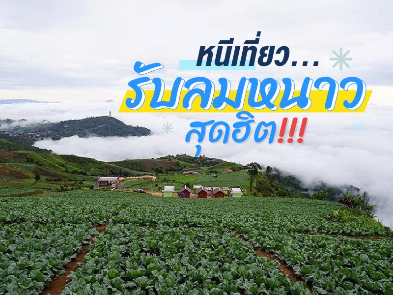 หลังจากเข้าหน้าหนาวอย่างเต็มตัว วันนี้เลยรวบรวมที่เที่ยวหน้าหนาวสุดฮิต มาให้ได้ชมกัน ซึ่งแต่ละที่มีความสวยงาม และเอกลักษณ์ต่างๆกันไป ไม่ว่าจะเป็นการชมทะเลหมอก การรับลมหนาวบนดอย การนอนดูดาว การผจญภัยต่างๆ แต่ที่เหมือนกันๆ ก็คือ อากาศที่เย็นสบาย ใครชอบหนาวขนาดไหน ก็ลองเลือกที่เที่ยวในสไตล์ของคุณกัน


Doi Luang Chiang Dao stands as a limestone peak reaching 2,225 meters above sea level, featuring distinct geological characteristics that are rare in this region. The landscape from the summit is majestic, characterized by complex mountain ridges, particularly the Pyramid Peak and the Three Brothers Peaks, which are often enveloped in a thick sea of mist during the morning. Visitors can experience...
read more


Phu Thap Boek is the highest mountain peak in Phetchabun Province and one of Thailand’s most popular destinations for nature lovers, photographers, and camping enthusiasts. Standing at approximately 1,768 meters above sea level, the mountain offers refreshing cool weather throughout the year. During winter, temperatures can drop to single digits, and frost can occasionally appear on the moun...
read more


Doi Samer Dao and Pha Hua Sing are iconic destinations in Nan province, known for their panoramic mountain scenery and enchanting morning sea of mist. This spot attracts countless nature lovers who wish to immerse themselves in the serene beauty of northern Thailand.
What makes this site truly special is its spectacular sunrise and sunset viewpoints. Visitors often camp overnight to witness the sh...
read more


Phu Kradueng National Park is a sandstone table-top mountain shaped like an inverted bell, covering approximately 348 square kilometers (217,575 rai). It was declared Thailand’s second national park in 1959 (B.E. 2502).
The summit plateau is about 60 square kilometers, serving as the main area for overnight stays and nature exploration. The Wang Kwang Visitor Center provides accommodation, c...
read more

Phu Soi Dao National Park is the ultimate pride of the Thai trekking scene, especially during the rainy season when lush greenery covers every inch of the landscape. The journey begins with a heart-pounding trek through five brutal hills, starting from Sending Relatives Hill all the way to Death Hill (Neun Morana)a slope so steep that your face almost touches your knees. However, this is the perfe...
read more
6
Pang Ung


Pang Ung, officially known as the Pang Tong 2 Royal Project (Pang Ung), is a large reservoir on a high mountain peak, surrounded by magnificent pine forests, earning it the nickname "Switzerland of Thailand." It is one of Mae Hong Son province's most popular tourist destinations, attracting visitors to experience its natural beauty, especially during the winter.
This place has a long history. Orig...
read more

Mueang Pai (Pai) is a district renowned for its nature-focused tourism and easygoing lifestyle. The town is situated in a valley surrounded by majestic mountains and forests, providing clean air and a peaceful, tranquil setting.
The town has a fascinating history, most notably the Tha Pai Memorial Bridge, which was built during World War II and remains a significant landmark telling stories of the...
read more
8
Khao Kho

Khao Kho is the definition of a vacation paradise in the lower northern region, earned the nickname Switzerland of Thailand. The name "Khao Kho" is derived from the Kho tree (Livistona speciosa), a palm species with fan-like leaves that grew abundantly in this area in the past. Beyond its atmosphere, the area holds significant history as a battlefield between the government and the Commu...
read more


Chiang Khan Walking Street is a prominent tourist attraction in Chiang Khan, Loei Province. The street is an old, peaceful area that comes alive in the evening as a walking street. Here, visitors can experience the authentic local lifestyle and enjoy the serene environment.
The walking street is filled with local shops selling regional handicrafts, traditional foods such as fresh rice noodles, spi...
read more
10
Phu Chi Fa


Phu Chi Fa is not just an ordinary viewpoint; it is an icon that anyone visiting Chiang Rai simply cannot miss. The name of the peak is derived from its amazing physical characteristic: a stone cliff with a sharp point pointing towards the sky. The tip of this cliff protrudes into Laos, meaning that when you stand at the peak, you experience standing on the edge of the sky with a clear view o...
read more


Phu Ruea National Park covers areas in Phu Ruea and Tha Li districts of Loei Province, with its northern boundary adjoining Laos. The park’s terrain resembles a large ship perched atop a high mountain, with some rocks shaped as if sculpted, locally called “Kwan Samor.” Surrounding peaks are often shrouded in mist, creating a serene atmosphere amid lush forests, covering an area o...
read more
12
Phu Thok


Phu Thok, meaning “isolated mountain” in the Isan language, is a massive sandstone mountain rising prominently from the surrounding plains of Bueng Kan. Its unique geographical feature gives it significance both in terms of natural landscape and spiritual value, especially as it has been developed into a meditation site known as Wat Jetiyakhiri.
The origin of this temple is closely lin...
read more


Pha Taem National Park is located in Khong Chiam District, Ubon Ratchathani Province, covering an area of about 340 square kilometers. The terrain is mainly composed of rugged high mountains, cliffs along the Mekong River, dry dipterocarp forests, mixed deciduous forests, and natural rock plateaus, home to diverse flora and fauna.
Before it was declared a national park, the Pha Taem area had been ...
read more

Doi Mae Salong or Santikhiri Village, has a fascinating history filled with struggle. It began around 1961 when the 93rd Division of the Chinese Nationalist Army (Kuomintang or KMT) migrated from Burma and established a base on this mountain under the leadership of General Lee Wen-huan and General Tuan Shi-wen. Initially, Doi Mae Salong was a "red zone" troubled by political conflict and drug...
read more


Doi Tung Royal Villa began in 1988 under the royal initiative of Princess Srinagarindra (the Princess Mother). She wished for a residence to closely oversee the development of the Doi Tung area. Her famous remark, "I will plant a forest on Doi Tung," led to the construction of this simple villa as a hub for transforming bald mountains into lush forests and sustainably improving the quality of life...
read more


Huai Nam Dang National Park spans across the rugged highlands of Mae Taeng District in Chiang Mai and Pai District in Mae Hong Son, serving as a vital natural corridor in Northern Thailand. Geographically, it is part of the Thanon Thong Chai Range, acting as a crucial headwater source for several major rivers, including the Mae Taeng and Pai Rivers. The geological landscape is characterized by ste...
read more


Khao Yai National Park is Thailand’s first national park, established on September 18, 1962, covering an area of over 2,168 square kilometers across four provinces: Nakhon Ratchasima, Prachinburi, Nakhon Nayok, and Saraburi. In 2005, it was declared a UNESCO World Heritage Site as part of the Dong Phayayen–Khao Yai Forest Complex.
The park features a mix of evergreen forests, grassland...
read more
18
Sangkhlaburi


Sangkhlaburi District (Sangkhlaburi) is a border district located in the western part of Kanchanaburi Province. It is surrounded by the Tenasserim Mountain Range and rich natural forests near the border with Myanmar. The area is widely known as the "Town of Two Cultures" because it is home to diverse ethnic groups including Thai, Mon, Karen, and Burmese communities that coexist harmoniously, creat...
read more


Khao Chang Phueak (Khao Chang Phueak) is one of Thailand’s most famous and challenging trekking destinations, located within Thong Pha Phum National Park in Kanchanaburi Province. Rising approximately 1,249 meters above sea level, it is the highest peak in the park and is best known for its dramatic ridge trail called the “Knife Edge Ridge.”
The trekking route is approximate...
read more


Thi Lo Su Waterfall is a gigantic limestone waterfall cascading down a steep cliff over 250–300 meters high. Its powerful flow resonates throughout the valley all year long. The original Karen term “Thi Lo Chue” means “water that falls forcefully and crashes onto the ground”, but the name was later mispronounced as “Thi Lo Su,” which some mistakenly transl...
read more


Doi Inthanon National Park, located in Chiang Mai Province, is home to the highest peak in Thailand — Doi Inthanon, standing at 2,565 meters above sea level. The park spans over 482.4 square kilometers and covers parts of Chom Thong, Mae Chaem, Mae Wang, and Doi Lo districts.
Shaped by the Himalayan mountain range, the park features a landscape of rugged high mountains running north to south...
read more
22
Mon Jam


Mon Jam is a famous getaway destination located on a mountain ridge within the Nong Hoi Hmong village area. Originally, this land was a degraded forest used for shifting cultivation. However, through the grace of King Bhumibol Adulyadej the Great, who established the Nong Hoi Royal Project Development Center, this soil was revitalized into a thriving temperate agricultural hub. Situated at an alti...
read more
23
Doi Angkhang


Doi Ang Khang possesses a deeply valuable history as the site of the Ang Khang Royal Agricultural Station, the first royal agricultural research station established by King Bhumibol Adulyadej the Great (Radama IX) in 1969. The creation of this station began when His Majesty traveled through opium fields and witnessed the shifting cultivation practiced by hill tribes. He initiated a royal project t...
read more

Doi Mae U Kho (Doi Mae U Kho) is a nationally famous natural tourist destination, especially for the beauty of its Mexican Sunflower fields that attract visitors from all over the world during the appropriate season.
This area has a long natural history, where wild Mexican Sunflowers have grown densely and spread to cover the entire mountain, creating an exceptionally beautiful natural phenomenon....
read more


Doi Phu Kha National Park is the source of numerous streams and holds an ancient history tied to the legends of Nan’s people. Situated at an altitude of 1,980 meters above sea level, it covers an area of approximately 1,050,000 rai, spanning Pua, Chiang Klang, Thung Chang, Mae Charim, Tha Wang Pha, Santi Suk, and Bo Kluea Districts.
The terrain consists of steep, rugged mountains with stunni...
read more
กำลังเป็นที่นิยม

8 World Heritage Sites of Thailand
Tracing Ancient Civilizations and Invaluable Forests Recognized by UNESCO Thaila..
10 Must-Visit Spots Along the Chao Phraya River, B
Exploring the Chao Phraya River offers one of the most complete experiences of B..
Attractive Beaches in Sattahip, Chonburi
For those looking to escape the hustle and bustle of Pattaya and experience calm..
10 Thai Costume Spots to Go Back in Time
Wearing traditional Thai costume and taking photos at beautiful places is more t..
Recommend trips
- Pilgrimage to the Sacred Sites
- Trip to Bhutan
- 10 Thai Costume Spots to Go Back in Time
- 10 Sacred Buddhist Sites Thai Temples in India–Nep
- The Four Holy Pilgrimage Sites
- Dream Destinations in Switzerland
- Top Paris Check-in Spots
- Must-Visit Check-in Spots in London
- Attractive Beaches in Sattahip, Chonburi
- 10 Must-Visit Spots Along the Chao Phraya River, B
- 8 World Heritage Sites of Thailand
- The Ultimate Ancient Villages in Japan
- 10 Must-Visit Places in Waterford
- Watsons Bay Half-Day Trip
- 10 Best Shopping Destinations in Bangkok
- 10 Must-Visit Spots in Koh Yao
- EBC - World-Class Trekking Route
- 10 Must-Visit Check-ins in Uthai Thani
- Giant Buddha Landmarks in Thailand
- Thailand Nature Trails