


ป่าเขา ธรรมชาติไกลสุดหล้า ต้องไปให้ได้
 29430
29430
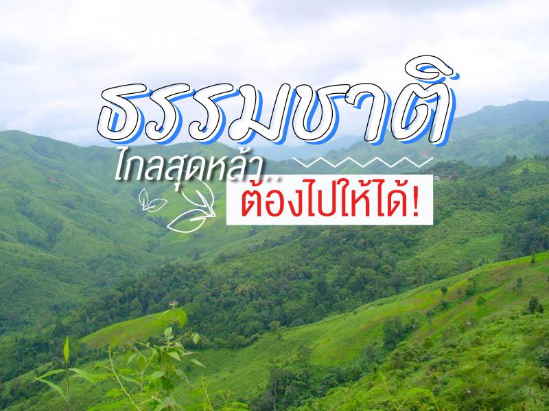 หน้านี้ แอดมิน เน้นเฉพาะ คนชอบภูเขา ธรรมชาติดิบๆ คัดสรรแบบ "ต้องไปให้ได้" แต่เดินทางลำบาก ฉะนั้น สถานที่ไหนเดินทางสะดวกไปกันบ่อย ไม่ค่อยเป็นธรรมชาติเท่าไร ก็เลยคัดออก อ่ะครับ


Doi Ang Khang possesses a deeply valuable history as the site of the Ang Khang Royal Agricultural Station, the first royal agricultural research station established by King Bhumibol Adulyadej the Great (Radama IX) in 1969. The creation of this station began when His Majesty traveled through opium fields and witnessed the shifting cultivation practiced by hill tribes. He initiated a royal project t...
read more


Huai Nam Dang National Park spans across the rugged highlands of Mae Taeng District in Chiang Mai and Pai District in Mae Hong Son, serving as a vital natural corridor in Northern Thailand. Geographically, it is part of the Thanon Thong Chai Range, acting as a crucial headwater source for several major rivers, including the Mae Taeng and Pai Rivers. The geological landscape is characterized by ste...
read more
3
Mon Jam


Mon Jam is a famous getaway destination located on a mountain ridge within the Nong Hoi Hmong village area. Originally, this land was a degraded forest used for shifting cultivation. However, through the grace of King Bhumibol Adulyadej the Great, who established the Nong Hoi Royal Project Development Center, this soil was revitalized into a thriving temperate agricultural hub. Situated at an alti...
read more


Doi Inthanon National Park, located in Chiang Mai Province, is home to the highest peak in Thailand — Doi Inthanon, standing at 2,565 meters above sea level. The park spans over 482.4 square kilometers and covers parts of Chom Thong, Mae Chaem, Mae Wang, and Doi Lo districts.
Shaped by the Himalayan mountain range, the park features a landscape of rugged high mountains running north to south...
read more


Doi Luang Chiang Dao stands as a limestone peak reaching 2,225 meters above sea level, featuring distinct geological characteristics that are rare in this region. The landscape from the summit is majestic, characterized by complex mountain ridges, particularly the Pyramid Peak and the Three Brothers Peaks, which are often enveloped in a thick sea of mist during the morning. Visitors can experience...
read more


Phu Chi Fa is not just an ordinary viewpoint; it is an icon that anyone visiting Chiang Rai simply cannot miss. The name of the peak is derived from its amazing physical characteristic: a stone cliff with a sharp point pointing towards the sky. The tip of this cliff protrudes into Laos, meaning that when you stand at the peak, you experience standing on the edge of the sky with a clear view o...
read more


Doi Mae Salong or Santikhiri Village, has a fascinating history filled with struggle. It began around 1961 when the 93rd Division of the Chinese Nationalist Army (Kuomintang or KMT) migrated from Burma and established a base on this mountain under the leadership of General Lee Wen-huan and General Tuan Shi-wen. Initially, Doi Mae Salong was a "red zone" troubled by political conflict and drug...
read more


Doi Samer Dao and Pha Hua Sing are iconic destinations in Nan province, known for their panoramic mountain scenery and enchanting morning sea of mist. This spot attracts countless nature lovers who wish to immerse themselves in the serene beauty of northern Thailand.
What makes this site truly special is its spectacular sunrise and sunset viewpoints. Visitors often camp overnight to witness the sh...
read more


Doi Mon Chong stands at approximately 1,929 meters above sea level, located on the border between Omkoi District in Chiang Mai and Sam Ngao District in Tak. The terrain is unique for its contrasting geography: one side features gentle, sloping meadows, while the other presents a sheer vertical cliff dropping into the valley below. The name "Mon Chong" comes from the local Lanna language, meaning a...
read more


Thi Lo Su Waterfall is a gigantic limestone waterfall cascading down a steep cliff over 250–300 meters high. Its powerful flow resonates throughout the valley all year long. The original Karen term “Thi Lo Chue” means “water that falls forcefully and crashes onto the ground”, but the name was later mispronounced as “Thi Lo Su,” which some mistakenly transl...
read more

Doi Phu Kha National Park is the source of numerous streams and holds an ancient history tied to the legends of Nan’s people. Situated at an altitude of 1,980 meters above sea level, it covers an area of approximately 1,050,000 rai, spanning Pua, Chiang Klang, Thung Chang, Mae Charim, Tha Wang Pha, Santi Suk, and Bo Kluea Districts.
The terrain consists of steep, rugged mountains with stunni...
read more


Phu Fa Development Center is one of the most important attractions in Nan province, located amidst lush mountains and unspoiled nature. The peaceful environment is perfect for visitors who wish to experience the authentic beauty of the natural landscape.
The center is special for being part of the Royal Project initiated by Princess Maha Chakri Sirindhorn, which promotes sustainability, environmen...
read more
13
Phu Tubberk


Phu Thap Boek is the highest mountain peak in Phetchabun Province and one of Thailand’s most popular destinations for nature lovers, photographers, and camping enthusiasts. Standing at approximately 1,768 meters above sea level, the mountain offers refreshing cool weather throughout the year. During winter, temperatures can drop to single digits, and frost can occasionally appear on the moun...
read more

Phu Hin Rong Kla National Park is a unique travel spot unlike anywhere else in Thailand. It doesn’t just have green forests, but it is also a land full of historical stories and strange-looking geological features. This area is located on the border of three provinces: Phitsanulok, Phetchabun, and Loei. This makes the weather cold almost all year, especially in winter when the temperature ca...
read more

Phu Soi Dao National Park is the ultimate pride of the Thai trekking scene, especially during the rainy season when lush greenery covers every inch of the landscape. The journey begins with a heart-pounding trek through five brutal hills, starting from Sending Relatives Hill all the way to Death Hill (Neun Morana)a slope so steep that your face almost touches your knees. However, this is the perfe...
read more
16
Pang Ung


Pang Ung, officially known as the Pang Tong 2 Royal Project (Pang Ung), is a large reservoir on a high mountain peak, surrounded by magnificent pine forests, earning it the nickname "Switzerland of Thailand." It is one of Mae Hong Son province's most popular tourist destinations, attracting visitors to experience its natural beauty, especially during the winter.
This place has a long history. Orig...
read more


Doi Mae U Kho (Doi Mae U Kho) is a nationally famous natural tourist destination, especially for the beauty of its Mexican Sunflower fields that attract visitors from all over the world during the appropriate season.
This area has a long natural history, where wild Mexican Sunflowers have grown densely and spread to cover the entire mountain, creating an exceptionally beautiful natural phenomenon....
read more


Chae Son Hot Springs is one of the most famous natural attractions in Lampang Province, located within Chae Son National Park. Nature created this site through a geological phenomenon where hot water emerges from the ground through various rock formations, spreading across an area of over 3 rai (approx. 1.2 acres). Its significance to the province is being the Thai Onsen, attracting people to...
read more


Phu Kradueng National Park is a sandstone table-top mountain shaped like an inverted bell, covering approximately 348 square kilometers (217,575 rai). It was declared Thailand’s second national park in 1959 (B.E. 2502).
The summit plateau is about 60 square kilometers, serving as the main area for overnight stays and nature exploration. The Wang Kwang Visitor Center provides accommodation, c...
read more


Pha Taem National Park is located in Khong Chiam District, Ubon Ratchathani Province, covering an area of about 340 square kilometers. The terrain is mainly composed of rugged high mountains, cliffs along the Mekong River, dry dipterocarp forests, mixed deciduous forests, and natural rock plateaus, home to diverse flora and fauna.
Before it was declared a national park, the Pha Taem area had been ...
read more

Kiriwong Village is an ancient settlement located at the foothills of Khao Luang, the highest mountain range in southern Thailand. The village was originally known as “Ban Khun Nam,” referring to its location near natural water sources, before later being renamed “Kiriwong,” meaning a village encircled by mountains. The community covers an area of more than 8,173 rai and is...
read more


Khao Sok National Park was declared a national park on December 22, 1980, covering 645.52 sq km (403,450 rai). It connects to Khlong Saeng Wildlife Sanctuary and Khlong Phanom National Park, forming vital wildlife corridors.
Geography: The park features rugged limestone peaks, cliffs, mysterious caves, and waterfalls. The northern area hosts a large water reservoir formed by Ratchaprapa Dam, surro...
read more
23
Khao Krachom

Khao Krachom, located in Suan Phueng District, Ratchaburi Province, is one of the most famous viewpoints for observing the sea of mist and sunrise in western Thailand. Situated in the Tenasserim Mountains near the Thai-Myanmar border, it sits at an elevation of approximately 1,000–1,045 meters above sea level, resulting in cool temperatures year-round. During the rainy and winter seasons, ...
read more

Khao Chang Phueak (Khao Chang Phueak) is one of Thailand’s most famous and challenging trekking destinations, located within Thong Pha Phum National Park in Kanchanaburi Province. Rising approximately 1,249 meters above sea level, it is the highest peak in the park and is best known for its dramatic ridge trail called the “Knife Edge Ridge.”
The trekking route is approximate...
read more


Ayerweng Sea of Mist (Ayerweng Sea of Mist) is located on a high mountain area in Betong District at an elevation of approximately 2,038 feet above sea level within the Hala-Bala rainforest, one of the most biodiverse and important tropical rainforest ecosystems in southern Thailand. The landscape is characterized by complex mountain ranges and deep valleys, which create ideal conditions for dense...
read more
กำลังเป็นที่นิยม

8 World Heritage Sites of Thailand
Tracing Ancient Civilizations and Invaluable Forests Recognized by UNESCO Thaila..
10 Thai Costume Spots to Go Back in Time
Wearing traditional Thai costume and taking photos at beautiful places is more t..
10 Must-Visit Spots Along the Chao Phraya River, B
Exploring the Chao Phraya River offers one of the most complete experiences of B..
Attractive Beaches in Sattahip, Chonburi
For those looking to escape the hustle and bustle of Pattaya and experience calm..
Recommend trips
- The Four Holy Pilgrimage Sites
- Dream Destinations in Switzerland
- 10 Thai Costume Spots to Go Back in Time
- Pilgrimage to the Sacred Sites
- Trip to Bhutan
- 10 Sacred Buddhist Sites Thai Temples in India–Nep
- Attractive Beaches in Sattahip, Chonburi
- Top Paris Check-in Spots
- Must-Visit Check-in Spots in London
- 10 Must-Visit Spots Along the Chao Phraya River, B
- 8 World Heritage Sites of Thailand
- The Ultimate Ancient Villages in Japan
- 10 Must-Visit Places in Waterford
- Watsons Bay Half-Day Trip
- 10 Best Shopping Destinations in Bangkok
- EBC - World-Class Trekking Route
- 10 Must-Visit Check-ins in Uthai Thani
- Giant Buddha Landmarks in Thailand
- Thailand Nature Trails
- 1-Day Kirribilli & Sydney Harbour Walking Tour