


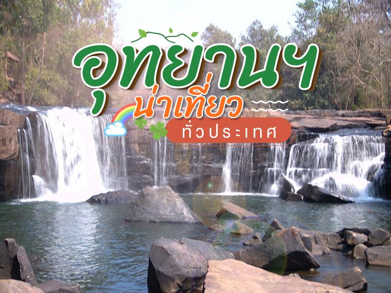
ชมอุทยานฯ น่าเที่ยว ทั่วประเทศ
 35999
35999

This national park offers a breathtaking view of the natural scenery of a steep river valley amidst scenic mountains and teak forests. It is about 105 kilometers from Chiang Mai town on Highway 108....
read more

Doi Suthep-Pui National Park covers areas in Mae Rim, Hang Dong, and Mueang Chiang Mai districts, with an area of approximately 262.50 square kilometers (163,162.50 rai). It consists of rich forests and complex mountains, including Doi Suthep (1,667 m), Doi Buak Ha, and Doi Pui (highest 1,685 m), which are the sources of important streams.
Major attractions and important sites within the park:
W...
read more

Doi Inthanon National Park, located in Chiang Mai Province, is home to the highest peak in Thailand — Doi Inthanon, standing at 2,565 meters above sea level. The park spans over 482.4 square kilometers and covers parts of Chom Thong, Mae Chaem, Mae Wang, and Doi Lo districts.
Shaped by the Himalayan mountain range, the park features a landscape of rugged high mountains running north to south...
read more

Huai Nam Dang National Park spans across the rugged highlands of Mae Taeng District in Chiang Mai and Pai District in Mae Hong Son, serving as a vital natural corridor in Northern Thailand. Geographically, it is part of the Thanon Thong Chai Range, acting as a crucial headwater source for several major rivers, including the Mae Taeng and Pai Rivers. The geological landscape is characterized by ste...
read more

Mae Surin Waterfall National Park is located in Mae Hong Son Province, covering mountainous terrain with rich forest ecosystems, and is a popular tourist attraction in Northern Thailand. Its highlight is the Mae Surin Waterfall, a majestic cascade about 180 meters tall, dramatically dropping from a steep cliff into the valley below. During the rainy season, the waterfall flows with power...
read more

Chae Son National Park possesses a historical background deeply intertwined with the way of life of the Mueang Pan people since ancient times. This area has long been revered as a sacred site and a precious resource that sustains communities around the Western Phi Pan Nam Range. Originally, locals referred to the area based on the physical appearance of hot springs emerging from rock formations. I...
read more

Doi Pha Khlong National Park covers parts of Long, Mueang Phrae, and Sung Men in Phrae Province. The park spans approximately 78,125 rai (125 square kilometers) and is characterized by steep mountain ranges and dramatic limestone landscapes rising 300–700 meters above sea level.
The area serves as an important watershed for the Yom River, with several tributaries including Huai Khamin, Huai ...
read more

Si Satchanalai National Park, formerly known as Mae Yom Forest, is one of the most significant and beautiful natural attractions in Sukhothai Province. Most of the area consists of steep mountains covered by lush deciduous and dry evergreen forests. This forest is a vital headwater source for many rivers that sustain the lives of people in Sukhothai and nearby provinces. The atmosphere within the ...
read more


Mae Ngao Rafting is a popular activity at Mae Ngao National Park, located in Ban Mae Ngao, Mae Suat Subdistrict. The river route is ideal for genuine rafting adventures, with natural landscapes on both sides well-preserved. It is also suitable for tourists who enjoy fishing. The distance from the district town via road and water to Ban Sop Moei, Um Lo, is approximately 35 km.
Mae Ngao River is a l...
read more

Thung Salaeng Luang National Park is the third-largest national park in Thailand, covering more than 789,000 rai across Phitsanulok and Phetchabun provinces. The park spans areas in Wang Thong and Nakhon Thai districts of Phitsanulok, as well as Lom Sak, Mueang, and Chon Daen districts of Phetchabun. It was officially declared a national park on 27 May 1975 to preserve watershed forests, wildlife ...
read more

Si Nan National Park covers approximately 583,750 rai, or 934 square kilometers, spanning several districts in Nan Province, including Wiang Sa, Na Noi, and Na Muen. The park’s mountains run north to south, with Doi Kham as the highest peak. It serves as a major source of the Nan River and offers diverse natural features, including both deciduous and evergreen forests. Important wildlife inc...
read more


Khun Sathan National Park covers a vast area with complex, steep mountains stretching from north to south, with the ridgeline of Doi Prae Mueang marking the boundary between Nan and Phrae. It is the source of numerous streams and tributaries. At the park’s watershed research station, wild Himalayan cherry trees and other flowers bloom beautifully during winter.
Most of the park is covered wi...
read more

Doi Phu Kha National Park is the source of numerous streams and holds an ancient history tied to the legends of Nan’s people. Situated at an altitude of 1,980 meters above sea level, it covers an area of approximately 1,050,000 rai, spanning Pua, Chiang Klang, Thung Chang, Mae Charim, Tha Wang Pha, Santi Suk, and Bo Kluea Districts.
The terrain consists of steep, rugged mountains with stunni...
read more

Doi Khun Tan National Park in the Lampang area holds immense significance as the starting point of a new chapter in northern Thailand's rail transportation. The Hang Chat District side of Lampang is the site of the Khun Tan Tunnel, the longest railway tunnel in Thailand (1,352.10 meters). Construction began during the reign of King Rama V under the supervision of German engineer Mr. Emil Eisenhofe...
read more


Phu Ruea National Park covers areas in Phu Ruea and Tha Li districts of Loei Province, with its northern boundary adjoining Laos. The park’s terrain resembles a large ship perched atop a high mountain, with some rocks shaped as if sculpted, locally called “Kwan Samor.” Surrounding peaks are often shrouded in mist, creating a serene atmosphere amid lush forests, covering an area o...
read more


Phu Kradueng National Park is a sandstone table-top mountain shaped like an inverted bell, covering approximately 348 square kilometers (217,575 rai). It was declared Thailand’s second national park in 1959 (B.E. 2502).
The summit plateau is about 60 square kilometers, serving as the main area for overnight stays and nature exploration. The Wang Kwang Visitor Center provides accommodation, c...
read more

Kaeng Tana National Park is located in Khong Chiam District, Ubon Ratchathani Province, covering approximately 80 square kilometers. It was established to conserve the large river rapids, the Mun River ecosystem, and the surrounding dry dipterocarp and mixed deciduous forests, which host a rich variety of flora and fauna.
Kaeng Tana features massive rock formations made of sandstone and granite, f...
read more

Khlong Lan National Park covers approximately 187,500 rai in Tambon Khlong Lan Phatthana, Tambon Khlong Nam Lai, and Tambon Pong Nam Ron, Khlong Lan District, Kamphaeng Phet, about 58 km from the provincial town. Established as Thailand’s 44th national park on December 25, 1982, it is an important natural area in western Thailand with mountainous terrain and serves as the source of several r...
read more

This national park can be reached via the Bangkok-Saraburi-Chai Badan route, then connecting to Highway No. 205 (Chai Badan-Thep Sathit-Chaiyaphum). Then take a left-hand road just before the district for 29 kilometres. The park is littered with large rocks of unusual shapes, some resembling a nail, a serpent’s head and an ancient castle. In the early part of the rainy season in...
read more

Khao Yai National Park is Thailand’s first national park, established on September 18, 1962, covering an area of over 2,168 square kilometers across four provinces: Nakhon Ratchasima, Prachinburi, Nakhon Nayok, and Saraburi. In 2005, it was declared a UNESCO World Heritage Site as part of the Dong Phayayen–Khao Yai Forest Complex.
The park features a mix of evergreen forests, grassland...
read more


The Tat Ton National Park covers some parts of Phu Laen Kha mountain range. To get there, take Highway No. 2051 for 21 kilometres. Tat Ton waterfall is an important tourist spot. The water here cascades down wide rock plateaus, creating breathtaking scenery, especially in the rainy season when there is plenty of water. The park also has Pha Iang waterfall, which is 32 kilometres from the city on t...
read more

Phu Wiang National Park is far more than just a lush forest in the Northeastern region of Thailand; it serves as a massive geological chronicle preserving the world's secrets from over 130 million years ago. The park features a unique topographical structure, characterized by a ring-shaped mountain range that encircles a vast inner valley. This natural fortress has created a specialized ecosystem ...
read more

Phu Pha Thoep National Park is a highly distinctive national park in northeastern Thailand, known for its exceptional geology, landscape, and ecosystems. It is located in Mukdahan Province near the Mekong River basin, which has played an important role in shaping its long-standing natural environment and biodiversity.The park consists of ancient sandstone mountains estimated to be around 90–...
read more

Pha Taem National Park is located in Khong Chiam District, Ubon Ratchathani Province, covering an area of about 340 square kilometers. The terrain is mainly composed of rugged high mountains, cliffs along the Mekong River, dry dipterocarp forests, mixed deciduous forests, and natural rock plateaus, home to diverse flora and fauna.
Before it was declared a national park, the Pha Taem area had been ...
read more

Phu Suan Sai National Park covers an area of approximately 73,225 rai (117 square kilometers), encompassing the high mountain ranges in the northern part of Loei Province, which continue to the border with Laos, with the Hueang River serving as a natural boundary.
The park’s terrain consists of complex mountains with elevations ranging from 600 to 1,408 meters above sea level. The highest pe...
read more


Erawan National Park (Erawan National Park) is one of the most important national parks in Kanchanaburi Province, covering approximately 343,750 rai (about 550 square kilometers). It was officially designated as Thailand’s 12th national park in 1975. Originally known as "Khao Salop National Park," it was later renamed Erawan National Park after the distinctive appearance of the waterfall&rsq...
read more

Sai Yok National Park is one of the most famous national parks in Kanchanaburi Province, covering over 500 square kilometers of forest in Sai Yok and Thong Pha Phum districts. It lies within the Tenasserim Mountains, a large, continuous forest area in western Thailand. The majority of the land consists of dry evergreen forest, mixed deciduous forest, and bamboo forest, interspersed with limestone ...
read more

Thong Pha Phum National Park covers vast fertile forest areas in Thong Pha Phum and Sangkhla Buri Districts of Kanchanaburi Province. The park is dominated by steep and complex mountain ranges, serving as the origin of several important waterways in western Thailand.
Located along the Tenasserim Mountain Range, the park forms part of a continuous forest ecosystem connected to Myanmar. It plays a v...
read more

Khao Khitchakut National Park is in the area of Khao Khitchakut or Khao Phat Forest, Makham District, and Khao Khitchakut Subdistrict, Chanthaburi Province. It has a rich natural scenery consisting of beautiful mountains and beautiful scenery. The highest peak is in altitude of 1, 000 meters has beautiful natural conditions, such as Bull Waterfall 100 meters away from the park office. It is ...
read more

Khao Laem Ya - Mu Ko Samet National Park is a significant marine national park in Rayong Province, covering coastal areas and islands in the Gulf of Thailand. Officially declared a national park in 1981, it encompasses over 80 square kilometers of land and sea, with the majority of the area being sea and rich coastal ecosystems. The park extends from Khao Laem Ya on the coast of Ban Phe to various...
read more

Phlio Waterfall National Park is a national park located in Chanthaburi Province. It covers areas within Mueang District, Laem Sing District, Khlung District, and Makham District, with a total area of approximately 134.50 square kilometers or 84,062.50 rai. The park features lush forests and a complex mountain range, which keeps the weather cool and pleasant throughout the year. Elevations ra...
read more

Kaeng Krachan National Park is one of Thailand’s most significant natural World Heritage sites, recognized for its outstanding ecological value in Southeast Asia. Covering more than 2,900 square kilometers across Phetchaburi and Prachuap Khiri Khan provinces, the park serves as a major watershed that feeds the Phetchaburi and Pranburi rivers, playing a crucial role in sustaining agriculture,...
read more


Khao Sam Roi Yot National Park was established as Thailand's first coastal national park, celebrated for its rare geographical distinction. It covers mountainous and marine areas in Sam Roi Yot District. The core structure consists of steep limestone mountain ranges contrasting sharply with the low-lying Sam Roi Yot Marsh, a large freshwater wetland area recognized as a Ramsar Site of global impor...
read more

Hat Wanakorn National Park is known for its calm seaside environment and long stretch of natural coastline. The sand on the beach is often reddish-brown and the shore slopes gently, making it safe for wading and swimming. The beach is lined with pine trees, creating a refreshing atmosphere and offering consistent shade for visitors seeking peace and relaxation.
Terrestrial and Marine Ecosystems
Th...
read more


Mu Ko Chumphon National Park was officially established on February 24, 1999, covering a total area of 198,125 rai (approximately 324.42 square kilometers), with more than 80% of the area being marine.
Originally proposed as "Hat Sai Ri National Park," it was renamed to reflect the geographical features that include numerous small and large islands—over 40 in total.
The park features a varie...
read more


Khao Sok National Park was declared a national park on December 22, 1980, covering 645.52 sq km (403,450 rai). It connects to Khlong Saeng Wildlife Sanctuary and Khlong Phanom National Park, forming vital wildlife corridors.
Geography: The park features rugged limestone peaks, cliffs, mysterious caves, and waterfalls. The northern area hosts a large water reservoir formed by Ratchaprapa Dam, surro...
read more


Sri Phang Nga National Park is one of the most pristine and ecologically rich forests in Phang Nga Province. Covering an area of more than 153,800 rai, the park lies along the Nom Sao mountain range, forming a natural boundary between Khura Buri and Takua Pa districts. This forest plays an important role as a natural watershed, feeding several streams and rivers that support nearby communities.
Th...
read more

Khao Lak–Lam Ru National Park is a protected natural area known for its unique combination of mountains, rainforest, and the Andaman Sea. Covering more than 78,000 rai across several districts of Phang Nga Province, the park features rugged mountain ranges that serve as the source of important streams and rivers supporting local communities in Takua Pa and Thai Mueang districts.
The park is ...
read more


Mu Ko Similan National Park has been rated first by the U.S. publication Skin Diving of the top ten dive sites in the world. Also, it is appraised by the Skin-Diving Magazine of USA as one of the top ten islands having both surface and under water beautiful scenery.
The Similan Island in the heart of the Andaman Sea are indeed unparelled in their exotic beauty. If planning a visit, keep in mind th...
read more
40
Koh Kam Tok

Koh Kam Tok has a curve-shaped inlet where the park protection unit in charge of guarding and providing facilitation to tourists is located. To reach the island, it takes 20 minutes by boat from Ko Khang Khao.
This panoramic view of the island is one of the famous destination among the tourist and local since the view is quite different to other island. It is the area of white sandy beac...
read more

Namtok Ngao National Park spans over 417,500 rai (approximately 668 square kilometers) across the Phu Kiew–Khao Pho Ta Chong Lo mountain range on the western side of southern Thailand.
The terrain is largely composed of steep mountain ranges that function as both a natural “lung” and “sponge,” absorbing moisture and regulating water flow. The park is covered by dense ...
read more


Laem Son National Park is a significant and famous location renowned for the abundant natural beauty of its marine environment. It occupies a total area of 315 sq. km. and is situated across Amphoe Mueang and Amphoe Kapoe in Ranong Province, extending to Amphoe Khura Buri in Phang Nga Province.
This area comprises approximately 60 kilometers of coastline and various islands in the Andaman Sea, inc...
read more

The national park is located at the coastal of the country there are magnificent views and scenery above the water surface its abundant with forest wetlands and also the source of plenty aquatic propagation. This island filled with beautiful scenery and that's why it became a National Park.
This National park at this declared a National Park on 29 April 2524. The National park contains of man...
read more

Sirinat National Park is a natural conservation area on the northwestern coast of Phuket Island, covering approximately 90 square kilometers of both land and sea. With sea cover accounting for about two-thirds of the total area, the park is significant for its marine and coastal ecosystems. A key highlight is its proximity to Phuket International Airport, making it one of the few places in Thailan...
read more
45
Mu Koh Surin


Mu Ko Surin consists of five main islands: North Surin, South Surin, Ko Ri, Ko Klang, and Ko Khai. It is one of Thailand’s most ecologically rich marine national parks, featuring lush tropical forests and vibrant underwater ecosystems
North Surin Island serves as the park headquarters, offering accommodations such as tents and bungalows, along with basic facilities for overnight stays
Snorke...
read more

This park covers an area of 45,000 rai and was proclaimed as a national park area on April 14, 1986. Places of interest in the vicinity of this national park are:
Lam Pi Waterfall a medium-sized waterfall. There are about 6 floors, water throughout the year. Origin from Lampi Waterfall. Especially in the rainy season. People to travel relax a lot.Ton Phrai Waterfall Km area. 28-29. laterite road s...
read more

Than Bok Khorani National Park is one of the forests and natural landmarks that most clearly reflects the valuable biodiversity of Krabi Province. While other national parks may present only one aspect of nature, Than Bok Khorani is a special area that combines the tranquility of tropical rainforest, the mystery of ancient caves, and the beauty of islands in the sea into one destination. The most ...
read more
48
Hong Islands

Hong Islands are widely recognized as one of Thailand’s most beautiful and geographically distinctive island groups. Nestled within the stunning Andaman Sea, the islands resemble a masterpiece sculpted by nature over millions of years, where dramatic limestone cliffs rise from emerald-green waters. What captivates visitors from around the world is the remarkable diversity of landscapes, comb...
read more


Hat Noppharat Thara - Mu Ko Phi Phi National Park is located in the Mueang Krabi District, spanning a vast area of approximately 387.9 square kilometers across both mainland and the fertile Andaman Sea. The geological landscape is defined by towering limestone karsts, an iconic symbol of Krabi’s coastline. The park's administrative heart lies at Hat Noppharat Thara, originally known by ...
read more

Hat Khanom–Mu Ko Thale Tai National Park is a marine national park currently under the process of legal establishment. Initial surveys and data collection were first conducted in 1990 to assess natural resources and environmental conditions in the area.
The proposed national park area includes parts of Khlong Thong Forest, Khlong Reng Forest, Khao Ok Forest, Khao Thong Node Forest, Khao Chai...
read more


Mu Ko Phetra National Park is a maritime conservation area of immense geological and ecological significance, stretching along the Andaman coast from Tung Wa and La-ngu Districts in Satun to Palian District in Trang. The landscape is characterized by towering limestone cliffs and islands shaped like Chinese junks, which inspired the name "Phetra" from the Javanese-Malay word for sailing vessel. Th...
read more


Thale Ban National Park is one of the most distinctive protected natural areas on Thailand’s Andaman coast. It is located along the Thailand–Malaysia border within the Sankalakhiri mountain range, which serves as a natural barrier and an important watershed supporting ecosystems across Satun Province.
The park’s most prominent feature is “Thale Ban Lake,” a lar...
read more
53
Koh Tarutao


Koh Tarutao the biggest island in the park where the park office is situated. The main island of Tarutao used to be a jail for convicts but now tourists can walk along trails to beaches and cliffs. The ruined prisons are found at Ao Talo Udang, on the southern tip of island and at Ao Talowao, on the middle of east coast. The island contains several bays including Ao Phante Malaka with a ...
read more


Mu Ko Lanta National Park is one of the most famous marine national parks in southern Thailand, covering numerous islands in the Andaman Sea. Officially established in 1990, the park spans more than 84,000 rai of protected land and sea, including tropical rainforest, coastal cliffs, coral reefs, and small islands rich in biodiversity. One of its most popular attractions is the Laem Tanod area, loc...
read more


Hat Chao Mai National Park is one of Thailand’s most important and beautiful marine national parks, covering areas on both land and the Andaman Sea, located within Sikao and Kantang Districts of Trang Province. The park spans more than 144,292.35 rai, featuring a unique combination of over 20 kilometers of coastline, limestone mountains, multiple islands, and highly abundant ecosystems.
Biod...
read more
กำลังเป็นที่นิยม
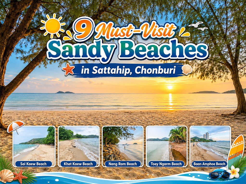
Attractive Beaches in Sattahip, Chonburi
For those looking to escape the hustle and bustle of Pattaya and experience calm..

10 Kanchanaburi Spots When the Rain Softly Falls
Kanchanaburi when the rain softly falls is a beautiful moment between the end of..
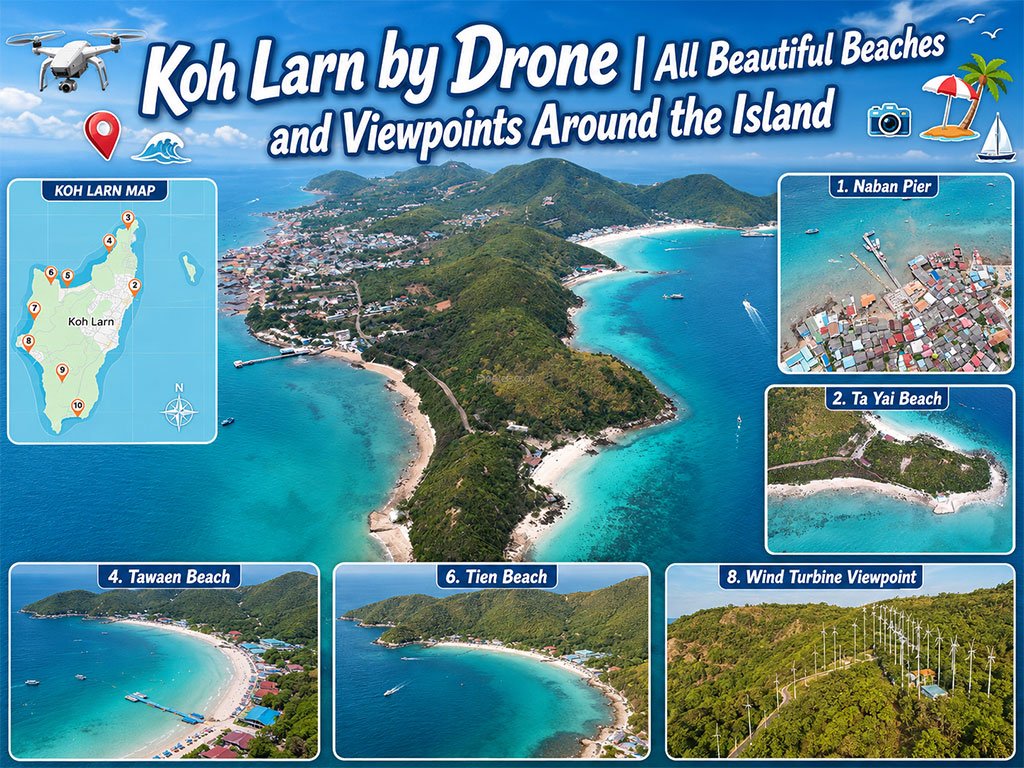
Koh Larn Aerial Views by Drone
Starting from Naban Pier, then looping north to Ta Yai Beach → Th..

10 Thai Costume Spots to Go Back in Time
Wearing traditional Thai costume and taking photos at beautiful places is more t..
Recommend trips
- Pilgrimage to the Sacred Sites
- Trip to Bhutan
- 10 Sacred Buddhist Sites Thai Temples in India–Nep
- Koh Larn Aerial Views by Drone
- 10 Kanchanaburi Spots When the Rain Softly Falls
- The Four Holy Pilgrimage Sites
- Dream Destinations in Switzerland
- Must-Visit Check-in Spots in London
- Attractive Beaches in Sattahip, Chonburi
- Top Paris Check-in Spots
- 10 Thai Costume Spots to Go Back in Time
- 10 Must-Visit Spots Along the Chao Phraya River, B
- 8 World Heritage Sites of Thailand
- The Ultimate Ancient Villages in Japan
- Thailand’s Sandbar Wonders
- 10 Must-Visit Places in Waterford
- 10 Best Shopping Destinations in Bangkok
- Thailand Nature Trails
- 10 Must-Visit Spots in Koh Yao
- EBC - World-Class Trekking Route